The Geography of Witchcraft Accusations in Salem Village 1692
(DRAFT NOT FOR QUOTATION OR CITATION)
(Click on map images for larger image, use "back" button
to return to text)
Benjamin C. Ray
University of Virginia
"The alleged witches and those who accused them resided
on opposite sides of the village." Boyer and Nissenbaum, 1974.
Paul
Boyer and Steve Nissenbaum’s influential study Salem
Possessed: The Social Origins of Witchcraft (1974) appeared a
little over one hundred years after the publication of the Reverend
Charles Upham’s now classic two-volume work, Salem Witchcraft
(1867)1. Like Upham's work, Salem
Possessed dwelt almost exclusively on Salem Village; and like
Upham, Boyer and Nissenbaum made significant use of a map of Salem
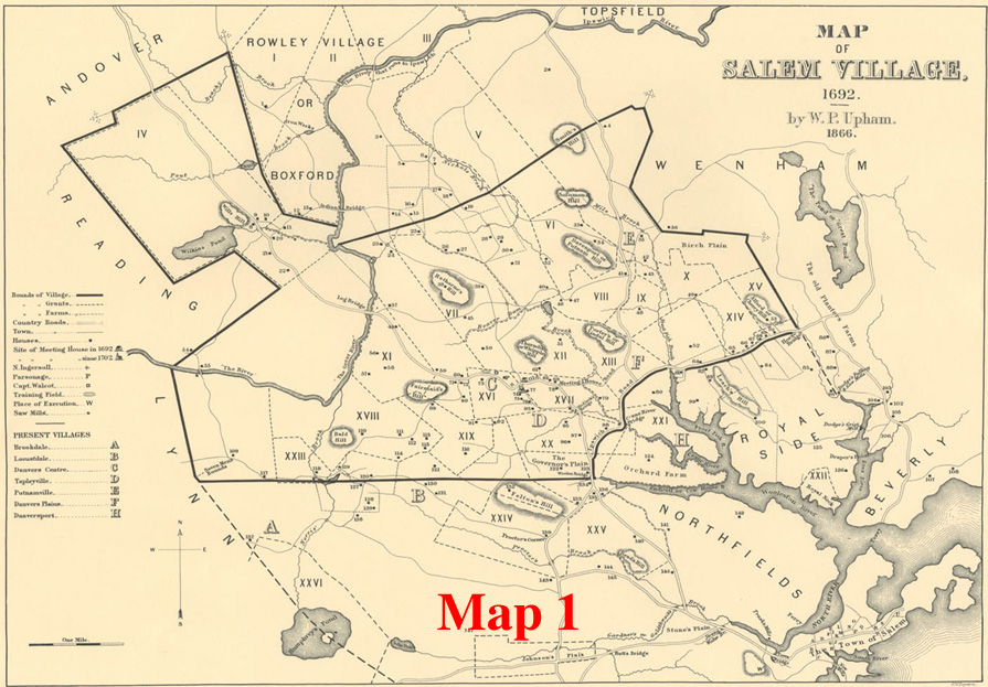
Village in 1692. 2 Upham's map showed the
locations of virtually all the households in Salem Village (See Map 1),
 and Boyer and Nissenbaum used this same map to plot
the locations of the accusers and the accused in the Village. As a
geographically based socio-economic study keyed to this map, Salem
Possessed succeeded so well in explaining the witchcraft
episode in Salem Village that it was not signifcantly challenged by
another scholarly account, until the appearance of Mary Beth Norton's
innovative and more comprehensive work, In the Devil's Snare,
in 20023.
and Boyer and Nissenbaum used this same map to plot
the locations of the accusers and the accused in the Village. As a
geographically based socio-economic study keyed to this map, Salem
Possessed succeeded so well in explaining the witchcraft
episode in Salem Village that it was not signifcantly challenged by
another scholarly account, until the appearance of Mary Beth Norton's
innovative and more comprehensive work, In the Devil's Snare,
in 20023.
The long-term success of Salem Posssessed, now in
its twentieth printing, can be attributed not only to its socio-economic
approach but also to its use of a simple but compelling map of the accusations
in Salem Village. 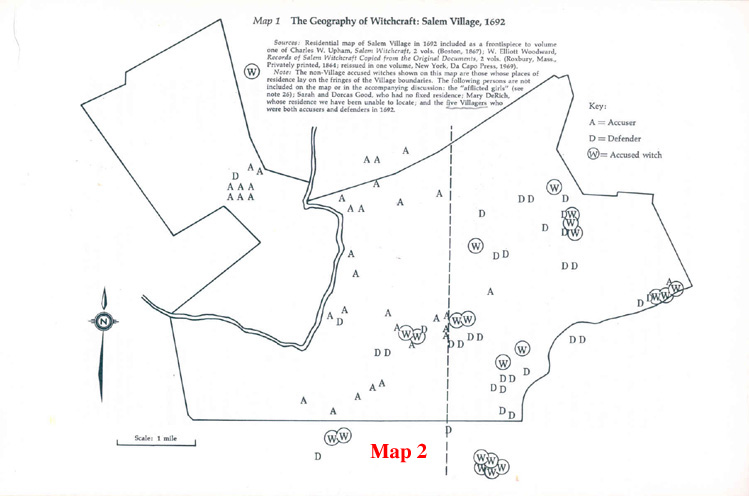 Drawing upon Upham’s accurate and
detailed map of the Village, Boyer and Nissenbaum created a map of Salem
Village (See Map 2) that used letters to mark the locations of the
individual accusers (A's), accused witches (W's), and defenders (D's).
The map appeared near the beginning of the book and presented a
surprising picture. It showed that "the alleged witches and those
who accused them resided on opposite sides of the village."4 Boyer and Nissenbaum followed this statement with
the question,"What are we to make of this pattern?" The rest
of their book gave the answer.
Drawing upon Upham’s accurate and
detailed map of the Village, Boyer and Nissenbaum created a map of Salem
Village (See Map 2) that used letters to mark the locations of the
individual accusers (A's), accused witches (W's), and defenders (D's).
The map appeared near the beginning of the book and presented a
surprising picture. It showed that "the alleged witches and those
who accused them resided on opposite sides of the village."4 Boyer and Nissenbaum followed this statement with
the question,"What are we to make of this pattern?" The rest
of their book gave the answer.
On the basis of
their map, Boyer and Nissenbaum argued that underlying the village
quarrels and the girls’ afflictions was a deep-seated economic
difference between the Village and the neighboring commercial Town of
Salem (of which Salem Village was a part), an economic difference that
eventually divided the Village geographically into two conflicting
groups. Boyer and Nissenbaum suggested that the poorer agrarian
householders who lived in the western side of the Village set their
hearts and fears against their more prosperous and commercially minded
neighbors who lived in the eastern part of the Village, nearer the
Town, and benefited from it economically. Over the years, Boyer and
Nissenbaum argued, the "town oriented" easterners consistently
thwarted the western farmers' efforts to gain independence from the Town
and thereby improve their economic standing. Ultimately, this economic
conflict led the frustrated westerners to respond by charging many of
the easterners with witchcraft. One summary of Salem Possessed
puts it this way: "The Salem trials can be seen as an indirect
yet anguished protest of a group of villagers whose agrarian way of life
was being threatened by the rising commercialism of Salem
Town."5
Several other maps in Salem Possessed reinforce this argument.
They depict the geography of the conflict in Salem Village over the new
minister, the Reverend Samuel Parris, and show the locations of the land
holdings of the influential Putnam and Porter families as evidence that
the Village was divided into eastern and western economic factions.
It is the striking map of the accusations in Salem
Village that appears to have been the most effective device in
supporting Boyer and Nissenbaum's interpretation. This map reduced the
whole complex episode to a single graphic image: A's on one side of the
Village, W's on the other. Finally, it seemed, the mystery of the
witchcraft accusations in Salem Village had been solved, by means of an
objective historical method..
Most American
history textbooks make reference to this map, and some repeat its
socio-economic interpretation. Indeed, the map is so widely referenced
in current textbooks that it is not an exaggeration to say that in
American history classrooms, the Boyer and Nissenbaum map has become
part of the Salem story, even in those textbooks that offer a different
point of view. At the more popular level, a current Salem
visitor’s guidebook recommends Salem Possessed as a
“seminal work that established the socio-economic and political
factors that brought about the witch hunt”.6 But, as Mark Monmier points out in How to Lie
With Maps, when it comes to cartography, the general public seldom
questions a map maker’s work and often fails to realize that
“catographic license is extremely broad."7 Perhaps it is not surprising that the Boyer and
Nissenbaum map has never been subject to thorough examination.
A review of the court documents shows shows that the Boyer and Nissenbaum map
of the accusations is, in fact, highly interpretive and considerably incomplete.
In the first part of this paper, I correct the map's many inaccuracies and
present as complete a picture as possible. In the second part, I present additional
maps that show relevant economic, social, and religious data in order to gain
further perspective on the demographic aspects of Salem Village.
My findings can be
stated at the outset. Contrary to Boyer and Nissenbaum’s
conclusions in Salem Possessed, geographic analysis of the
accusations in the Village shows that there was no significant
Village-wide, east-west division between accusers and accused in 1692.
Nor was there an east-west division between households of different
economic status. Equally important, eastern Village leaders were not
opposed to the Village's attempts to gain independence from Salem Town.
To be sure, Salem Village suffered from years of internal conflict over
its ministers and replaced them at an unusually frequent rate. But these
conflicts did not have an east-west geographic or economic character.
The Village was in fact remarkably homogeneous in its geographic
distribution of wealth at almost all economic levels during this period.
The same distribution holds true of the Village’s religious and
social demography.
Before examining the map more closely, I want to comment on its overall purpose in Salem Possessed. It might appear that the map carries the burden of the argument about the socio-economic and geographic foundation of the witchcraft accusations. But the map’s footnotes indicate that it is more properly understood as an illustration of the socio-economic argument, not its proof. Indeed, the map is introduced to the reader as a kind of geographic clue to the rest of the book. Unfortunately, Boyer and Nissenbaum’s use of the map confuses these two purposes, as clue or proof. On the one hand, their quantitative approach to the map -- comparing the numbers of As, Ws, and Ds that appear on the eastern and western sides of the map -- suggests that the map presents objective evidence of a geographically divided village and that it reveals a straightforward numerical pattern. On the other hand, the explicit statements in the footnotes explain that the map deliberately omits a number of well-known accusers, some because of their youth, others because of their support for some of the accused. These omissions indicate that the map involves an important interpretive component. It is also implied that the map is complete, except for the specified omissions. As we shall see below, this is not the case. The map therefore stands in an unclear relation to the information contained in the court records: it is both interpretive and incomplete while being offered to the reader as objective and complete.
The purpose of this paper is to argue that before any explanatory interpretations
can be brought to bear on a map of the accusations in Salem Village, it will
first be necessary to present as objective and complete a map as possible
based on the court records. All maps involve interpretation, of course,
but there
is a difference between necessary map-making interpretations of a set of
data and interpretations built into the map that already present a perspective
on
the data the map represents. Here I shall make my interpretative choices
and method of representation as transparent as possible. Digital processing
makes
this task somewhat easier because of the ease of sorting, displaying, and
labeling the data, as well as the explicit database requirement for documentation
and
decision making about every data point that appears on the map. The next
step would be to pose a lot of questions, for example, to locate the most
frequent
accusers in the village and ask what they have in common, geographically
or otherwise, and then to do the same for the accused. The basis for any
such
geographic questions, however, will be an accurate map of the accusers and
accused.
I
In order to explain the errors
and assumptions involved in Boyer and Nissenbaum’s map of the
Village accusations, it will be necessary to understand how the map was
made. Boyer and Nissenbaum used Upham’s map of Salem Village in
1692, which is a detailed and fairly accurate rendering of Salem Village
house locations. and geographic boundaries (see Map 3). 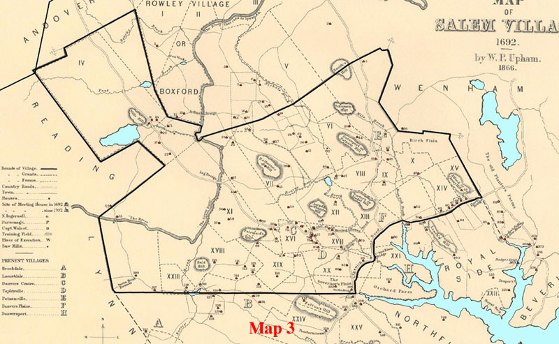 Upham placed numbers and symbols
on the map to designate the locations of 150 houses and structures in
Salem Village and neighboring townships. Each number stands for the name
of a householder, and correlates with Upham’s list of names of
property owners in 1692. For example, number twenty-four designates the
house of Thomas Putnam, which was the home of four accusers: Thomas
Putnam, Ann Putnam, Sr., Ann Putnam, Jr., and Mercy Lewis. Upham’s
map also plots, with less detail, the locations of several witchcraft
related sites in nearby Salem Town.
Upham placed numbers and symbols
on the map to designate the locations of 150 houses and structures in
Salem Village and neighboring townships. Each number stands for the name
of a householder, and correlates with Upham’s list of names of
property owners in 1692. For example, number twenty-four designates the
house of Thomas Putnam, which was the home of four accusers: Thomas
Putnam, Ann Putnam, Sr., Ann Putnam, Jr., and Mercy Lewis. Upham’s
map also plots, with less detail, the locations of several witchcraft
related sites in nearby Salem Town.
In the
process of digitizing and georeferencing Upham’s map, using
Geographic Information Systems (GIS) software, I placed red dots on each
of Upham's numbered house locations (See Map 3). The dots indicate
geographic points with coordinates in real geographic space. To
correlate Upham's map with geographic reality, I selected some of the
extant 1692 houses which were still standing on their original
foundations, represented by numbers on Upham’s map, and a few
stable landscape features. Using a geographical positioning system
device, I determined the latitude and longitude of these locations on
site. These known coordinates served as control points that linked the
digital version of Upham's map to real geographic space for purposes of
rectifying its errors as best as can be done using GIS software. The
process resulted in a very slight warping and stretching of the digital
image of Upham's map. The consequent offset between Upham's paper map
and geographic accuracy averages approximately 500 feet, which is
sufficiently accurate for my purposes.8
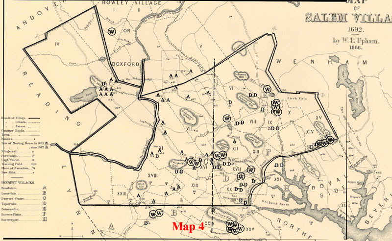 Placing a digital image of the Boyer and
Nissenbaum accusations map, with its black letters, A's, W's, and D's,
over the geo-registered Upham map provided a means for checking the
accuracy of Boyer and Nissenbaum’s map and also a useful way to
correlate its otherwise anonymous A's, W's, and D's with Upham's
household numbers. (See Map 4.) The correlation between the letters and
the house numbers turns out to be fairly close, except in the area at
the center of the map where the corrrelation is very inexact.
Nevertheless, by using the court documents and Boyer and Nissenbaum’s
census of the Salem
Village households it is possible to identify the people in those
households with their roles in the witch trials as accusers, accused,
and defenders, and locate them accurately on the map.9
Placing a digital image of the Boyer and
Nissenbaum accusations map, with its black letters, A's, W's, and D's,
over the geo-registered Upham map provided a means for checking the
accuracy of Boyer and Nissenbaum’s map and also a useful way to
correlate its otherwise anonymous A's, W's, and D's with Upham's
household numbers. (See Map 4.) The correlation between the letters and
the house numbers turns out to be fairly close, except in the area at
the center of the map where the corrrelation is very inexact.
Nevertheless, by using the court documents and Boyer and Nissenbaum’s
census of the Salem
Village households it is possible to identify the people in those
households with their roles in the witch trials as accusers, accused,
and defenders, and locate them accurately on the map.9
Boyer and Nissenbaum
placed an all-important east-west demarcation line at the center of
their map, without explaining why they placed it where they did. This is
curious because it is evident that positioning this line very slightly
to the west would make a significant difference in the crowded center of
the map, shifting several A's to the eastern side of the Village. See
the close-up image, Map 5, which focuses on this area and shows the
dotted demarcation line neatly dividing A's and W's. 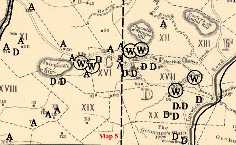 I shall take up the question of the positioning of this
line later on.
I shall take up the question of the positioning of this
line later on.
The numerical count of A's, W's, and D's that accompanies the map in Salem Possessed refers to accusers, accused, and defenders located within the Village boundaries, even though the map itself shows a number who are located outside Village in neighboring settlements. The map indicates that there were fourteen accused witches, thirty-two accusers, and twenty-nine defenders in the Salem Village. Elsewhere, Boyer and Nissenbaum give different tallies of accusers and accused. For example, Boyer and Nissenbaum's documentary source book Salem-Village Witchcraft (1972) lists twenty-six accused witches as Village residents. Included in this list are eight people who are shown on the map in Salem Possessed as living outside the Village boundaries.10 A subsequent map published in Paul Boyer's co-authored volume, The Enduring Vision: A History of the American People (1995), shows only eleven accused witches within the Village borders.11
There is a similar problem with the number of
accusers in the Village. The map in Salem Possessed shows there
are twenty-nine A's in Salem Village, whereas the numerical count that
accompanies the map says that there are thirty-two. This number
includes three "As" located just over the Village's northern
broundary in Topsfield.
For the sake of completeness, my
corrections to the A's, W's, and D's on the map includes those located
both inside and outside Salem Village boundaries, within the same
geographic area as Boyer and Nissenbaum's map. Even though it is evident
that the social network of the Village accusers reached far beyond the
Village's borders, making local geographic boundaries largely irrelevant
to understanding all but the initial stage of the episode, for the
purposes of this paper I will retain Boyer and Nissebaum’s focus
on the Village and its immediate environs, in the exactly same area
where they placed their A's, W's, and D's. The immediate environs
include adjacent areas of Topsfield and Salem Farms. Widening the map's scale
would introduce other issues that lead beyond Boyer and Nissenbaum's
interpretion of the outbreak of the accusations in the Village, which is
the focus of this paper. I also stay within the same time frame as the
dates of those accused on the map, from the end of February to the end
of May, the first three months of the full nine-month period of
accusations.
Starting with the accused persons
represented by W's, I have already noted that none of the letters on the
Boyer and Nissenbaum map are identified by name. The identity of the W's
is evident, however, from an unpublished version of the map which
assigns names to each of them and locates them in the same positions as
the map in Salem Possessed. See Map 6.12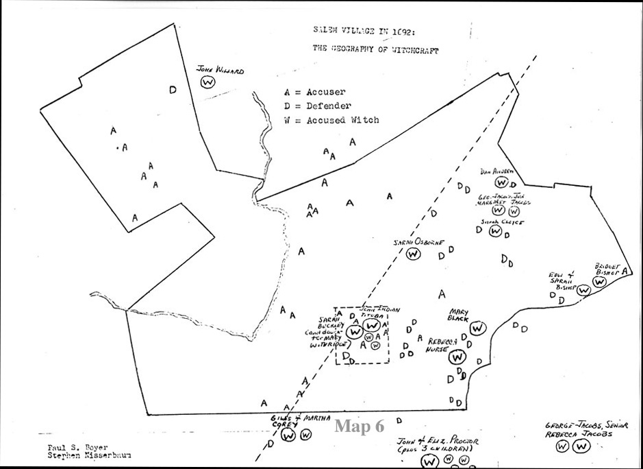
.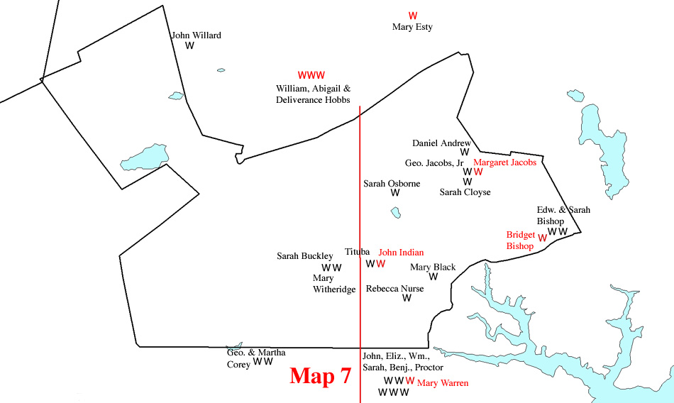
Using these names, Map 7 identifies each W on the map in Salem Possessed and indicates in red letters eight W's that need to be corrected, deleted, or added. The red W furthest to the east represents Bridget Bishop. Subsequent scholarship has shown that she did not live in the Village but in the Town, and hence the placement of this W is incorrect and should be deleted.13 The red W near the center of the Boyer and Nissenbaum map is one of a pair representing Tituba and John Indian, two Indian slaves who lived in the house of the Reverend Samuel Parris. The same pair of W's appears in the same location on the unpublished map (see Map 6) and clearly represents the same two persons. John Indian, however, was never accused of witchcraft, although he himself was an active accuser in some of the grand jury hearings. Nor is John Indian identified as one of the accused witches in Boyer and Nissenbaum's list in their source book, Salem-Village Witchcraft. The W representing him on the map in Salem Possessed is therefore a mistake and should be deleted. It was possibly an uncorrected error that was carried over from the unpublished version of the map shown above. Boyer and Nissenbaum have also mistakenly placed Margaret Jacobs, daughter of George Jacobs, Jr. in her father's house in the Village, whereas according to the court records she lived in Salem Town with her grandfather, George Jacobs, Sr. Rebecca Jacobs, however, lived with her husband George in the Village, not in her father-in-law's house in Salem. All the other W's located within the Village boundaries are correct according to the court records and require no comment.14
Turning now to the W's located outside the Village,
the cluster of five located to the southeast just below the Village
boundary represent five members of the John Proctor family who were
accused (John Proctor, his wife Elizabeth, and three of their children,
William, Benjamin, and Sarah). The Proctors did not live in the Village
but in the area called Salem Farms, an inland segment of Salem Town
immediately to the south of the Salem Village boundary.15 Thus John Proctor was not listed on the Village
tax roles. He was also a prominent member of the church in Salem Town
since 1667 and remained so until his execution as a witch in 1692.
During the witchcraft episode, Proctor's great
mistake was to denounce the accusing girls and scoff at their
afflictions, especially those of his twenty-year-old servant, Mary
Warren, whom he is said to have beaten to stop her fits. Mary Warren
lived as a servant in the Proctor house and was a close friend of the
young female accusers in Salem Village. She was an active accuser in
her own right and was herself accused of witchcraft when she confessed
in the court, saying that the other afflicted girls "did but
dissemble." To rectify the map, then, an additional W needs to be
placed at the location of the Proctor household to represent the accused
status of Mary Warren, as well as an additional A to represent Warren's
double role as an accused-accuser.
The W located to the northwest just beyond the Salem Village boundary in the area of Rowley Village (now Boxford) marks the house of John Willard, as indicated on Upham's map. Property deeds show that Willard's large holdings lay within the Will's Hill area of Salem Village,16 in the northwest corner, and hence Willard's name regularly appears on the Village tax lists. Willard served as a deputy constable at the time of the witchcraft accusations and was involved in arresting several Villagers, but he is said to have quit this work out of conscience. He was subsequently accused, arrested, and eventualy executed. Curiously, Boyer and Nissenbaum do not include Willard in their numerical tally of accused Village witches in Salem Possessed, even though he is consistently identified as a resident of the Village in the court documents and tax records.
Also curious is the omission of four accused witches, shown here as red W's, who lived in the neighboring town of Topsfield, just to the north of Salem Village. In this area, Boyer and Nissenbaum placed three A's to represent three Topsfield accusers, Phillip and Margaret Knight and Lydia Nichols but unaccountably omitted four accused witches who lived nearby. In late April 1692, Phillip and Margaret Knight and Lydia Nichols accused their immediate neighbors William, Deliverance, and Abigail Hobbs, who were also accused by several residents of the Village. In response to her accusation, Abigail Hobbs freely confessed to being a witch and, in turn, accused the Rev. George Burroughs. In the same week, several Village residents, including members of the Putnam family, also accused Mary Towne Easty, the wife of Isaac Easty, whose two sisters Rebecca Nurse and Sarah Cloyce had already been accused in the Village. All four Topsfield residents were well-known to their accusers in Salem Village, and they were quickly caught up in the early phase of the Village accusations. I have therefore added four W's to repersent them in their correct locations.
Map 8, then, 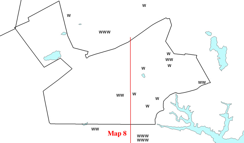 is the fully corrected representation of the locations
of those accused of witchcraft in Salem Village and the bordering areas
of Topsfield and Salem Farms, within the same area as the Boyer and
Nissenbaum map..
is the fully corrected representation of the locations
of those accused of witchcraft in Salem Village and the bordering areas
of Topsfield and Salem Farms, within the same area as the Boyer and
Nissenbaum map..
Turning now to the large
number of A's, Boyer and Nissenbaum tell us that they decided not to
represent on the map two categories of accusers. The first category is
an unnamed group of five accusers who "were both defenders and
accusers in 1692." The second category is the most active group of
accusers in the Village, "the eight 'afflicted girls'," as
Boyer and Nissenbaum call them.17 Thus,
thirteen accusers were omitted from the map.
Omitting these thirteen accusers turns out to make an
important difference because ten of them lived on the eastern side of
the Village, which significantly changes the east-west ratio of
accusers. The decision not to represent these thirteen well-documented
accusers indicates that Boyer and Nissenbaum did not intend their map to
represent information strictly as recorded in the court documents but,
rather, to present an interpretation of the court documents based on
their assumptions about the actors' motivations. It turns out that
several more accusers were also omitted, mainly, it would seem, by
oversight.18 Map 9  shows the names and locations of
all the accusers and identifies the ommitted persons by red A's.
shows the names and locations of
all the accusers and identifies the ommitted persons by red A's.
Looking first at the five omitted accusers who were
also defenders, Boyer and Nissenbaum do not tell us who they were, only
that they were not marked on the map as A's or D's. From the list of
defenders presented in the source book Salem-Village
Witchcraft, it is clear that by “defenders” Boyer and
Nissenbaum have in mind two categories of people: “individuals
testifying in defense of those accused witches who lived in Salem
Village” and “everyone giving skeptical testimony designed
to cast doubt on the credibility of the afflicted girls.”19 Examining the court documents, it is possible to
identify five defenders who were also accusers, who do not appear as A's
or D's on the accusations map. They are as follows: Nathaniel Putnam,
Jonathan Putnam, Joseph Herrick, Sr., Samuel Sibley, and James Holton.
The first four were defenders of Rebecca Nurse. James Holton was a
defender of John Proctor. None appear on the map as A's or D's, and all
were accusers of other people.
In addition to these five omitted accusers, it turns out that there are five more individuals who appear on the map as D's who were also accusers of other people but do not appear on the map as A's. These five are: Joseph Hutchinsin, Sr., his wife Lydia Hutchinson, John Putnam, Sr. and his wife Rebecca Putnam, and Joseph Holton, Sr. In light of Boyer and Nissenbaum's comment about the omission from the map of individuals who were "both accusers and defenders," it would appear that the reader is apparently to assume that any of the accusations made by these individuals should not be taken seriously, hence their omission as A's.
The decision to
omit those who accused some people and defended others, while perhaps
appealing to a modern sense of rationality, imposes an unfounded
interpretation upon historical events. The fact is that some of the
Villagers genuinely believed that some of the accused were guilty and
that others were not, and they acted on their convictions. Their
complaints and depositions appear in the records of the grand jury
hearings and most were used in the trials. That they believed Rebecca
Nurse or John Proctor to be innocent does not give us any grounds for
supposing that they came to doubt their own accusations against other
people or were skeptical about the trials in general.
Nathaniel Putnam, for example, acted as one of the
complainants in the arrest warrant against John Willard and Sarah
Buckley. He also initiated a complaint against Elizabeth Fosdick and
Elizabeth Paine, two women who lived in Malden. In the case of his pious
neighbor Rebecca Nurse, however, Putnam submitted a petition on behalf
of her innocence and also signed a testimonial circulated by the Nurse
family. Likewise, Jonathan Putnam accused both Mary Easty and Rebecca
Nurse, but later signed the petition in defense of Rebecca Nurse,
although he did not change his testimony against Rebecca's sister, Mary
Easty. Joseph Herrick, Sr., a constable in Salem Village who made a
number of early arrests of witchcraft suspects, submitted testimony
against Sarah Good but later signed the petition in defense of Rebecca
Nurse. Samuel Sibley testified against Sarah Good and John Proctor and
later signed the petition in support of his neighbor Rebecca Nurse.
Joseph and Lydia Hutchinson were among the original complainants against
Tituba, Sarah Osborne, and Sarah Good but both stood by their neighbor
Rebecca Nurse. Joseph Hutchinson also submitted a deposition that cast
doubt upon the testimony of Abigail Williams, one of Nurse's young
accusers. John Putnam, Sr. and his wife Lydia Putnam testified in court
against the former Village minister the Reverend George Burroughs, but
both came to the defense of Rebecca Nurse. Finally, Joseph Holton, Sr.,
who signed the petition for Rebecca Nurse, was one of the chief
complainants against William Proctor and several Andover people. There
is no indication in the documents that any of these six accusers
“publicly showed their skepticism about the trials,” as
Boyer and Nissenbaum suggest. I have therefore represented them on the
map as "As" in accordance with the court records.
Three other accusers, however, present a more complex
picture, suggesting that they may well have doubted the justification of
their accusations. James Kettle initiated a deposition against Sarah
Bishop, based on spectral testimony given to him by Elizabeth Hubbard.
Later, it seems, Kettle spoke with Hubbard, but this time submitted a
deposition accusing her of "severall untruthes." Thus Kettle
may have had second thoughts and wanted to put on record his doubts
about the reliability of Hubbard's testimony against Sarah Bishop, even
though it concerned the death of his own two children. James Holton
contributed testimony supporting the depositions of Mary Walcott and
Elizabeth Hubbard against John and Elizabeth Proctor. Nevertheless, both
he and his wife Ruth signed a petition on behalf of the Proctors'
innocence. At John Proctor's trial, however, James Holton's testimony
against Proctor was used in court, indicating that the court, at least,
had no doubts about the strength of Holton's convictions. John Putnam,
Sr. accused Rebecca Nurse of afflicting his son Jonathan but later
signed a peitition in her defense as did his son Jonathan. Nevertheless,
Putnam, Sr.'s testimony against Nurse was used in court at her trial,
while the petition for Nurse was not. Even though these accusers may
have had doubts about their initial accusations, their testimonies lent
support to the accusations in the Village, and they became part of the
evidence against the accused. I have therefore placed these three
accusers on the map as A's to reflect the court records.
It is significant that all ten of these accusers
lived on the eastern side of the Village. Whether Boyer and Nissenbaum
deliberately discredited their accusations to keep them "off the
map" and thereby reduce the number of A's on the eastern side is
unknown. But if a map of the accusations is to represent the historical
record, then all ten accusers must be represented in their role as
accusers.
Turning now to the omission of the
eight "afflicted girls," Boyer and Nissenbaum give us their
names: Sarah Churchill, Elizabeth Hubbard, Mercy Lewis, Elizabeth
Parris, Ann Putnam, Jr., Mary Warren, Mary Walcott, and Abigail
Williams. The residences of these eight accusers are well-known. To this
group we can add two more who were apparently overlooked: eighteen
year-old Susanna Sheldon, and ten-year-old Jemima Rea. Boyer and
Nissenbaum explain that they omitted all the young accusers because
"we think it to be a mistake to treat the girls themselves as
decisive shapers of the witchcraft outbreak as it evolved."
Subsequent scholarship, however, has made it clear
that this assumption, based as it is on the view that the
“afflicted girls” were merely mouthpieces for adult
male villagers, is entirely unsupportable. Bernard Rosenthal's careful
analysis of the court documents in Salem Story (1993)20 illuminates the constant collaboration among the
young accusers, quite independently of adult control, as well as their
deliberate acts of lying and deception. Mary Beth Norton's illuminating
study of these same young females in In the Devil's Snare makes
it abundantly clear that they were largely initiators of the accusations
in the Village and that they maintained control of the dynamics of the
accusations almost on a daily basis, both inside and outside the
courtroom. Although it can be said, as Norton points out, that two or
three of the youngest girls were initially prompted by adults to name
certain people as witches, these girls and their older female friends
clearly initiated most of the accusations on their own relying on
face-to-face encounters, village gossip, and frequent collaboration.
This, of course, does not minimize the role of
the adults who were heavily involved in enabling and supporting the
accusations. Norton emphasizes the fact that without leading village men
(the most active being the village clerk Thomas Putnam) who filed
official complaints and depositions on behalf of the afflicted junior
females, legal proceedings would never have occurred. Samuel Parris, who
was responsible for raising the subject of demonic activity in the first
place, supported the accusers from the beginning and gave the afflicted
girls widespread exposure through group fasts and prayer sessions. But
it was the girls and young women themselves who took the initiative in
naming names and, most importantly, in performing their afflictions in
numerous court sessions. They were called upon repeatedly by the
magistrates to give dramatic testimony during the seven months of
hearings and trials, and they obliged the court with ever escalating
effect, naming victims in a progressively widening social and geographic
circle through the spring, summer, and fall of 1692.
Restoring all ten junior female accusers to the map as A's makes a difference in east-west pattern because seven of them lived on the eastern side of the demarcation line: Elizabeth Parris, Abigail Williams, Jemima Rea, Elizabeth Hubbard, Susannah Sheldon, Mary Warren, and Sarah Churchill.21
I have also added eleven additional red A's to
represent eleven adult accusers that Boyer and Nissenbaum apparently
overlooked.
Their omission is surprising because three of them, the Reverend Samuel
Parris, John Indian, and Tituba were residents of the prominent Parris
household, and these three accusers figure significantly in the court
documents. I have placed them at the position of the Parris house,
located just to the east of the Boyer and Nissenbaum demarcation line,
and grouped them together with the two A's representing Abigail Williams
and Betty Parris in this same house. In the Parris household there was a
total of five accusers, more than any other household in the Village.
Eight other red A's represent the following: Deliverance Hobbs and her
daughter Abigail Hobbs, who confessed and accused several villagers who
had already been accused; Lydia Nichols, and her daughters Lydia and
Elizabeth and her son Thomas, who accused Abigail Hobbs and John
Willard; Joseph Whipple, who accused two women from Malden; Sarah Holton
who accused Rebecca Nurse; and Mary Herrick who, together with her
husband Joseph, accused Sarah Good.
To sum up,
then, the corrected map of the accusations in Salem Village shows an
additional thirty-one accusers, most of whom lived on the eastern side
of the Village. Putting accusers and accused together on the same map
(Map 10)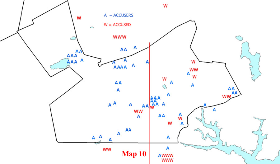 shows that there is no
pronounced east-west division. Thirty-one accusers appear on the eastern
side of the east-west line and thirty-six on the west. Thus, the
east-west ratio is nearly even. Alhough the east-west distribution of
accused witches is less even, there are enough in the west so that the
situation is not one sided. Clearly, accusers and accused did not live
"on opposite sides of the village." Mapping the accusations in
the Village and the nearby areas of Topsfield and Salem Farms does not
reveal a community geographically divided against itself.
shows that there is no
pronounced east-west division. Thirty-one accusers appear on the eastern
side of the east-west line and thirty-six on the west. Thus, the
east-west ratio is nearly even. Alhough the east-west distribution of
accused witches is less even, there are enough in the west so that the
situation is not one sided. Clearly, accusers and accused did not live
"on opposite sides of the village." Mapping the accusations in
the Village and the nearby areas of Topsfield and Salem Farms does not
reveal a community geographically divided against itself.
At this point it is useful to consider the location of
the Boyer and Nissenbaum's east-west demarcation line whose position is
not explained in Salem Possessed. If it were a strictly
geographical demarcation, dividing the Village into two equal parts, the
line would have to be moved further to the west in order to adjust for
the large geographical appendage, called Will's Hill, in the
northwestern corner. This configuration would shift several more A's to
the eastern side, and it does not appear to be what Boyer and Nissenbaum
had intended.
Perhaps the line was supposed to
be located nearer to the meeting house, the traditional symbolic center
of Puritan communities. If so, it should be moved very slightly to the
east. The location of the meeting house was selected in 1673 by Joseph
Hutchinson, Sr. who donated a plot of land from his own property. The
site was suitable because it placed the meeting house more or less
equidistant from most of the Village residents, and thus it stood at the
Village's approximate demographic center. Moving the line closer to the
meeting house would not significantly change the east-west ratio of accusers
to accused as Boyer and Nissenbaum represented it.22
It is interesting to
note that the unpublished version of the accusations map, mentioned
above (see Map 6)shows a diagonal line instead of
a vertical line, dividing the village in half from the northeast to
southwest. This line appears to have been drawn so that it placed as
many W's as possible on the eastern side of the Village. This strategy
left eight A's on the eastern side. Comparing the diagonal version with
the vertical one, which shows only two A's in the east, suggests that
the purpose of the vertical arrangement was to keep as many W's as
possible in the east and as many A's in the west. Placing the vertical
line so that it almost-too-neatly separates the closely clustered
households at the center, placing several A's to the west of it,
strengthens this interpretation. I would conclude, therefore, that the
placement of the vertical demarcation line on the map in Salem
Possessed was intended to show as dramatically as possible that
Salem Village was geographically divided against itself, placing nearly
all the A's in the west, and the majority of the W's in the east.
II
It will now be
useful to gain a more comprehensive view of the economic and social
demography of the village. According to Salem Possessed, there
was a deep-seated economic division between the more prosperous and
commercially minded, "town-oriented" farmers on eastern side
of the village and the poorer agrarian farmers in the west. Using the
same village tax information as Salem Possessed, Map 11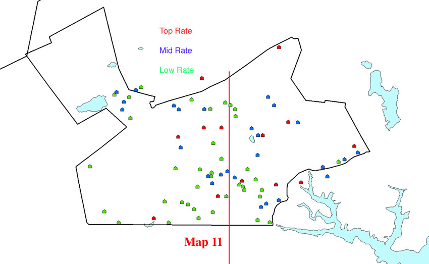 shows the three different tax levels in a single
display for the year 1689-90, two years before the outbreak of the
accusations.23 At the lowest tax level,
there are twenty-six households on the western side and thirteen on the
eastern; thus about twice as many of the poorest families (in terms of
land holdings) lived in the western area. The middle tax range shows
twelve households in the west and fifteen in the east, an almost even
distribution. The top level tax range includes six households in the
west and seven in the east, again, an almost even distribution. Except
for the lowest economic range, the map reveals a fairly homogeneous
distribution of wealth across the village. Salem Village was not a
community divided into radically differrent eastern and western economic
groups, and the tax records do not reveal any significant change over
time.
shows the three different tax levels in a single
display for the year 1689-90, two years before the outbreak of the
accusations.23 At the lowest tax level,
there are twenty-six households on the western side and thirteen on the
eastern; thus about twice as many of the poorest families (in terms of
land holdings) lived in the western area. The middle tax range shows
twelve households in the west and fifteen in the east, an almost even
distribution. The top level tax range includes six households in the
west and seven in the east, again, an almost even distribution. Except
for the lowest economic range, the map reveals a fairly homogeneous
distribution of wealth across the village. Salem Village was not a
community divided into radically differrent eastern and western economic
groups, and the tax records do not reveal any significant change over
time.
Map 12 shows the distribution of social, political, military,
administrative, legal, and religious leadership in the village during
the ten-year period 1680-1690.24 The
household markers on the map represent the households of church deacons,
village committee men, constables, village clerks, and militia officers,
as well as the village physician and the minister. Although there is a
slight bias toward the east by two households, the map shows a
homogeneous distribution of Village leaders over this ten-year period.
These are the men who were the most committed to the Village's welfare.
Although some of them also held positions in the Town Committee from
time to time, it can by no means be said that the commitment to Village
interests as measured by participation in its governance, was largely an
affair of the householders living in the west.
shows the distribution of social, political, military,
administrative, legal, and religious leadership in the village during
the ten-year period 1680-1690.24 The
household markers on the map represent the households of church deacons,
village committee men, constables, village clerks, and militia officers,
as well as the village physician and the minister. Although there is a
slight bias toward the east by two households, the map shows a
homogeneous distribution of Village leaders over this ten-year period.
These are the men who were the most committed to the Village's welfare.
Although some of them also held positions in the Town Committee from
time to time, it can by no means be said that the commitment to Village
interests as measured by participation in its governance, was largely an
affair of the householders living in the west.
Nevertheless, according to Boyer and Nissenbaum, it was the eastern Village leaders who deliberately hindered the western Villagers' long struggle for independence because the easterners' connections with the Town were economically beneficial to them. These eastern men, according to Salem Possessed, tried to undermine the Village's newly established congregation by attempting to oust the Reverend Samuel Parris, which would set back the Village’s efforts to become an independent township. An ordained minister and covenanted congregation of professed "elect" members were the necessary features in any Puritan town, and destabilizing the new church would frustrate the Salem Village's cause.
To investigate the role of
the eastern Villagers in the struggle for independence involves
examining the several petitions submitted to Salem Town and the General
Court in Boston in the years 1670 to1692. These petitions requested
release from the Town's ministry tax in order to collect a tax for a
Village minister. For most Villagers, travelling the five to ten miles
to Salem's meeting house, especially in the winter, was a hardship, and
this was the basis for petitions for a separate ministry and meeting
house in the Village.
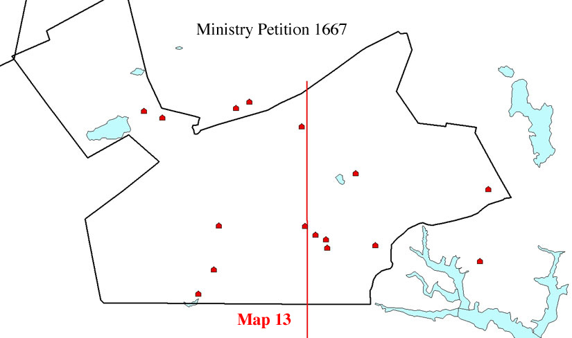 Map13
shows the wide geographic spectrum of Villagers who supported the
petition of 1670 for an independent minister in the village. From the
beginning, the General Court in Boston made it clear that the support of
the ministry and maintaining the meeting house would be in the hands of
all the members of the Village, not just those who were already
covenanted members of Salem Town's congregation. This created an unusual
situation in the Village -- indeed a structural anomaly -- since the
control of a town's ministry was normally in the hands of the members of
a congregation alone. But Salem Village was not an independent town and,
prior to the arrival of Samuel Parris, the Village had a meeting house
but no separately covenanted congregation. A small number of the
Villagers were members of the congregation in the Town, and a few
belonged to churches in neighboring Topsfield and Beverly, but a large
number were not members of any congregation. In 1679 the Salem church
reiterated the policy that the Village ministry was in the control of
all the inhabitants: "the liberty granted to them by the town of
Salem, whereby the Court order (to have a minister amongst themselves
with such bounds [of the Village]) was not granted to any of them under
the notion of church members, but to the whole number of inhabitants
there -- for their present ease, being so far from the meeting-house
here [in Salem Town]."25 This ruling
set the stage for possible conflict between future church members in the
Village, once an independent congregation was established there, and the
rest of the Village residents if they disapproved of the minister.
Map13
shows the wide geographic spectrum of Villagers who supported the
petition of 1670 for an independent minister in the village. From the
beginning, the General Court in Boston made it clear that the support of
the ministry and maintaining the meeting house would be in the hands of
all the members of the Village, not just those who were already
covenanted members of Salem Town's congregation. This created an unusual
situation in the Village -- indeed a structural anomaly -- since the
control of a town's ministry was normally in the hands of the members of
a congregation alone. But Salem Village was not an independent town and,
prior to the arrival of Samuel Parris, the Village had a meeting house
but no separately covenanted congregation. A small number of the
Villagers were members of the congregation in the Town, and a few
belonged to churches in neighboring Topsfield and Beverly, but a large
number were not members of any congregation. In 1679 the Salem church
reiterated the policy that the Village ministry was in the control of
all the inhabitants: "the liberty granted to them by the town of
Salem, whereby the Court order (to have a minister amongst themselves
with such bounds [of the Village]) was not granted to any of them under
the notion of church members, but to the whole number of inhabitants
there -- for their present ease, being so far from the meeting-house
here [in Salem Town]."25 This ruling
set the stage for possible conflict between future church members in the
Village, once an independent congregation was established there, and the
rest of the Village residents if they disapproved of the minister.
After repeated conflict and a succession of three
ministers in the Village in eighteen years, the last of whom was Deodat
Lawson who left in 1687, the Town finally permitted the Village to
recruit a new minister and establish its own covenant congregation. The
search for a new minister and the recruitment of Samuel Parris was the
work of a small village committe. After initial negotiations with Samuel
Parris concerning salary and benefits, which were not fully resolved,
the Village agreed to appoint Parris in November 1689. As the first
ordained minister in the Village, Parris could establish the Village's
first covenant congregation and baptize their children. This was also a
major step in the Village's progress for independence from the Town.
Once Parris was selected and installed, the Village
leaders lost no time in submitting petitions to the General Court in
Boston for indepdenent township status. The first peitition was
initiated in August 1689; another was submitted in December 1690; and
still another in January 1692.26 The final
petition of January 28, requested that the Village be granted township
status and be freed from the Town's taxes that did not benefit the
Village, namely, the taxes for Salem's minister, the Town roads, and
support the Town's poor. The petition was supported by several prominent
residents, all eastern Village men: John Putnam, Nathaniel Putnam,
Thomas Flint, Joseph Hutchinson, Francis Nurse, and Joseph Porter. (See
Map 14) 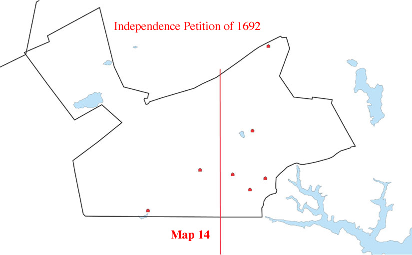 The first three were men who
strongly supported Parris, and the last three were adament opponents.
Despite the deepening conflict over Parris, the anti-Parris leaders
steadfastly backed the independence movement in cooperation with their
opponents.
The first three were men who
strongly supported Parris, and the last three were adament opponents.
Despite the deepening conflict over Parris, the anti-Parris leaders
steadfastly backed the independence movement in cooperation with their
opponents.
As can be seen from the accompanying map which shows the location of men supporting the petition of January 1692, the Village's desire for independence was strongly supported by eastern leaders. It is difficult, then, to agree with Boyer and Nissenbaum that eastern Village leaders had little "genuine" interest in separation from the Town. Indeed, all Villagers would benefit economically because independence would free the Village from paying a sizable portion of the Town's taxes for the support of its ministry and roads. Loss of tax revenue, however, made the Town reluctant to accept the Village's petitions. Athough there is a obvious connection between the establishment of the Village congregation and the Village independence movement, since an independent church was a requirement for township status, there is no exclusive connection between the geographic location of the men supporting the Village independence movement and the supposedly pro-independence western side of the Village, as Boyer and Nissenbaum believed..
Conclusion
The central idea of the Salem Possessed, which made it the landmark study that it was, was the notion that the Salem witch trials “cannot be written off as a communal effort to purge the poor, the deviant, or the outcast,” as in most of the other witchcraft episodes in New England. "Whatever was troubling the girls and those who encouraged them," Boyer and Nissenbaum observed, "it was something deeper than the kind of chronic, petty squabbles between near neighbors which seem to have been at the root of the earlier and far less severe witchcraft episodes in New England." This “something deeper” was Salem Village’s well-known factionalism and conflict that Boyer and Nissenbaum believed was fundamentally economic and geographic in character. Guided by this central idea, Salem Possessed, unlike accounts of the previous two hundred years, was the first to examine analytically the historical forces at work in Salem Village, instead of merely offering moral judgments on the episode and its many unfortunate participants.
Boyer and Nissenbaum were not misguided, however, in looking for a deeper
cause for the outbreak of the accusations, something deeply motivating
all the
grudges,
jealousies,
and fears mentioned in the witchcraft accusations. The question of Village-wide
factionalism is still a central one. In a subsequent article, I shall look
further into the nature of the Village conflict and its relation to the
witchcraft accusations
and the way it shaped the language of the accusations.
***************
I wish to express my appreciation to the Electronic Cultural Atlas Initiative for supporting the digital mapping of Salem Village. I am also greatly indebted to Mike Furlough, Blair Tinker, and Scott Crocker at the Geostat Center at the University of Virginia Library for their assistance in creating the GIS maps of Salem Village. I am, of course, responsible for their content and interpretation. Thanks also to Anne K. Knowles for her assistance with an earlier version of this paper, "Teaching the Salem Witch Trials," in Past Time, Past Place: GIS for History, edited by Anne Kelly Knowles (Redlands: ESRI Press, 2002). At the time of writing that essay I had not fully investigated the number of accusers in Salem Village and their relationship to the village church, nor did I focus on the inaccuracies of the Boyer and Nissenbaum map. I am also indebted to Margo Burns, Erik Midelfort, Mary Beth Norton, Marilynne Roach, and Bernard Rosenthal for reading the present essay and giving me most useful suggestions.
Notes
1. Paul Boyer and Steven Nissenbaum, Salem Possessed: The Social Origins of Witchcraft. HarvardUniversity Press, Cambridge. 1974. Salem Witchcraft, Charles W. Upham, Vols. I & II. Wiggin and Lunt, Boston 1867.
2. The map was made by Charles Upham’s brother W. P. Upham and is dated 1866. For purposes of digitization, I used an enlarged copy of this map printed by the Danvers Alarm List Company, Inc. n.d.
3. Mary Beth Norton, In the Devil’s Snare: The Salem Witchcraft Crisis of 1692. Alfred A. Knopf, New York, 2002.
5. James West Davidson and Mark Hamilton Lytle, After the Fact: The Art of Historical Detection. 3rd. edition. McGraw-Hill, Inc.: New York, 41.
6. List the titles of the American history textbooks here. Frances Hill, Hunting for Witches: A Visitor’s Guide to the Salem Witch Trials. Commonwealth Editions. Beverly, Mass.: 2002,136. The map has appeared in prominent television productions about the Salem witch trials. It has been given a signficant role in Three Soveriengs for Sarah and in the recent History Channel program titled “Witch Hunt,” (October 31, 2004)in which Paul Boyer and Steven Nissenbaum explain the map’s significance – (insert here a quote from the TV program).
7. Mark Monmier, How To Lie With Maps. University Of Chicago Press: Chicago, 1991. p.
8. See “The Salem Witchcraft GIS:A Visual Re-Creation of Salem Village in 1692” http://fisher.lib.virginia.edu/libsites/salem/.
9. Paul Boyer and Steven Nissenbaum, eds., Salem-Village Witchcraft: A Documentary Record of Local Conflict in Colonial New England. Northeastern University Press: Boston, 1993: 383-393. Here I follow Boyer and Nissenbaum's use of the term "accuser" to refer to anyone whose testimony in support of a charge of witchcraft was recorded in a court document. There are a variety of documents in which such testimonies appeared; they are commonly classified as: "complaints," "depositions," "testimonies," and "examinations." Like Boyer and Nissenbaum, I also count as accusers men who initiated complaints on behalf of others, most often girls and young women (who under Puritan law had no legal standing) who claimed to be victims of witchcraft. The most active complainant in Salem Village was Thomas Putnam, who initiated over 100 of them. I also count as "accusers" those who made charges against the accused directly before the magistrates during the examinations or signed as witnesses to depositions against the accused. Like Boyer and Nissenbaum, I use the term "accused" to refer to anyone named in a court document on the basis of testimony by an accuser. Other historical sources give the names of additional persons who were said to have been accused or "cried out" upon but were never formally charged in a legal document or the documents are now missing from the surviving records, and these I have not counted.
10. Salem-Village Witchcraft, 376- 78.
11. Paul S. Boyer,
Enduring Vision: A History of the American People, 2nd Ed. Vol.
1, Lexington, Mass: D. C. Heath & Co. 1993, 49.
12. This map bears the names of Paul S. Boyer and Stephen Nissenbaum in the lower left corner. It was found in a folder of miscellaneous papers relating to Salem witchcraft in the Phillips Library of the Peabody Essex Museum. The map includes the names of two accused witches George Jacobs, Sr. and Rebecca Jacobs located in the Northfields section of Salem, to the east of the Village. These names were omitted from the published map in Salem Possessed.
13. David Greene, ”Salem Witches I: Bridget Bishop,” The American Genealogist, 57 (1981):129-138.
14. The location of the Sarah Good and her five-year-old daughter Dorothy Good is not precisely known. According to the court records, Sarah Good and her husband William Good lived in Salem Village, probably in rented rooms, but their place of residence at the time of her accusation is not given in any records and therefore cannot be represented on the map.
15. Salem Village was originally part of Salem Town and was often referred to as "Salem Farmes" or simply “the Farmes." In 1672 several prominent residents of the Farms succeeded in petitioning the Town and the General Court for the authority to organize a parish called Salem Village for the purpose of hiring a minister and building a meeting house of their own. The boundaries of Salem Village were geographically defined at this time and given more or less precision, as represented on Upham's map. The residents within the Village established a separate tax list for themselves to support the village ministry, and the village residents were supposed to be freed from paying taxes to Salem Town for the preaching there. The remaining area of "the Farmes" located to the south of the Village remained part of the Town and came to be known as Salem Farms. The property owners of Salem Farms were taxed as “country” residents of the Town and were expected to attend Town meetings and belong to the Town church. The property owners living within the boundaries of Salem Village were first listed on the Village tax roles in 1681. The Village tax roles were updated every two or three years and thus constitute a record of the property owners in the Village. The inhabitants of the Village met regularly in the Village meeting house to handle their affairs, which mainly concerned the Village ministry and taxes and, later, petitions for independence from the Town.
16. Upham indicates that the location of this house is uncertain (Salem Witchcraft, Vol. 1: xix). Based on analysis of property deeds, Marilynne Roach has suggested that John and Margaret Knight Willard may have been living in the Will’s Hill area, perhaps with Margaret’s maternal relatives, near the large Wilkins clan who lived in this part of the village (personal communication, October, 2005).
18. Working with over 930 documents published in the three volume edition of The Salem Witchcraft Papers is not an altogether easy task. The Index to these volumes includes about one third of the names mentioned in the court records, and some documents pertaining to accused persons are only to be found in the case records of other people. Finding all the people named in the court records is both easier and more accurate when using the search tools associated with digital text edition at <http://etext.virginia.edu/salem/witchcraft>.
19. Salem-Village Witchraft. 381.
20. Bernard Rosenthal, Salem Story: Reading the Witch Trials of 1692. Cambridge: Cambridge University Press, 1993.
21. Sarah Churchill is not shown on the map because the residence of George Jacobs, Sr., where she lived, was located in the Northfields area of Salem that lies outside the range of the Boyer and Nissenbaum map. There are four additional accusers in Salem Farms who lived in the Alice Schaflin house (Alice Booth, Elizabeth Booth, George Booth, & wife Elizabeth). The Schaflin house also lies just outside the frame of the Boyer and Nissenbaum map.
22. The map of Salem Village in Paul Boyer's The Enduring Vision appears to locate the dividing line somewhat to east of the meeting house.By contrast, historian George Lincoln Burr refers to Ingersoll's Taven as the "recognized centre of the 'village.' The meeting-house [property] adjoined to the east, to the west the parsonage, where lived Mr. Parris." (Burr, Narrtives, p. end note 19.) This would place the dividing line further to the west, thus shifting a number of A's to the east.
23. "Ihe Salem Village Book of Records, 1672-1697" (Transcribed in the Historical Collections of the Danvers Historical Society, Vols. ) as printed in Salem-Village Witchcraft, 353-355;Salem Possessed, 82. Boyer and Nissenbaum use the tax rate list for the year 1695 -- well after the witch trials were over. The tax rates do not vary much between the 1689-90 and 1695 lists. For some reason, Boyer and Nissenbaum use the 1695 village tax rates as a basis for examining the economic situation that prevailed before the witchcraft accusations were made in 1692 that was supposedly the cause of the accusations.
24. Salem-Village Witchcraft, 319-355.
25. Salem-Village Witchcraft, 246.
26. Salem-Village Witchcraft, 349-357.