
Charlottesville shared in the general post-World War II prosperity of the country as banks, business and transportation continued to expand. With the support of the GI Bill, the University experienced a rapid expansion as the areas largest employer. The physical growth of the campus occurred in the central grounds area and out toward the west and southwest, away from the downtown district. In addition to the effects of the University's growth, tourism began to play an increasingly important role in the area's economy. Before the war, the Thomas Jefferson Memorial Foundation purchased Monticello and along with the University of Virginia grounds, this proved to be a major tourist attraction for the area.
In the late 1950's and 1960's a bypass was constructed to divert traffic away from the downtown district. This allowed a smooth connection between the north-south route to Washington/Lynchburg with the east-west connector of Route 250 (paralleling the old Three Notch'd Road). In addition, a major east-west interstate was constructed (Route 64) passing a mile south of the town center.
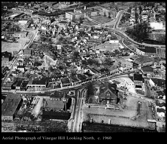
These major highway improvements were a part of the national campaign to improve commerce and ease of travel in general. Another trend that Charlottesville experienced in the late 1950's and early 1960's also paralleled accepted doctrinaire planning practice of the time. Amidst relatively little controversy, and with a very thinly disguised racist agenda, the city decided to exercise "urban renewal" with the neighborhood of Vinegar Hill. This process of slum clearance occurred in tandem with a particularly tense and incendiary situation surrounding desegregation in general and school desegregation in particular. At the time, the exclusively white high school (Lane High) was located at the base of the Vinegar Hill neighborhood and the principal black school (Jefferson School) was located on the western edge. While the city was only temporarily successful in fighting the federal mandate for school integration, the impact of the city's treatment of the Vinegar Hill residents and urban fabric produced a profound and long lasting effect. As a part of this agenda, around five-hundred black residents of the city were displaced, and the primary commercial district for the town's African-American community was destroyed. In place of this active neighborhood, the city installed a major north-south connecting road (McIntire) facilitating relatively high speed connections between Ridge Street and the Route 250 bypass. Eventually, a number of larger scale commercial buildings, a courthouse, apartments and condominiums and a hotel were constructed, situated typically amidst large areas of parking. In the mid-1970's, the city also decided to eliminate car traffic on Main Street downtown in favor of exclusive pedestrian access. The construction of the Mall was a part of this larger urban renewal strategy, attempting to staunch the flow of business activity away from the city center. Meanwhile, absent any significant zoning constraints within the county, the 1970's and 1980's witnessed extraordinary and virtually uncontrolled growth of strip developments in the peripheral areas of town.
| Charlottesville Brief Narrative | Charlottesville Railroads | Charlottesville Late 19th and Early 20th Century | Charlottesville Brief Notes |
 Charlottesville Archive
| Bibliography | Make a suggestion |
 IATH WWW
Server
IATH WWW
Server
 Return
to beginning
Return
to beginning