|
Marginal Landscapes
As Critical Infrastructure: Boston's Back Bay Fens
Kathy Poole
Published in the Proceedings of the
Annual Meeting of the Association of Collegiate Schools of Architecture,
Los Angeles, CA, 10-14 April 2000. Copyright Kathy Poole, all rights reserved
Abstract
Urban landscapes have particularly important roles in the continuous project
of building the city. Landscapes, as evolving infrastructures, take on
various forms, functions, and dynamics in relation to the surrounding
city. They embody expressive relationships that mirror changing cultural
relationships between nature and city. They are physical relationships
with a potentially powerful role in structuring the city. They are social
relationships that demonstrate the value of infrastructure in making places.
The essay explores these potentials through the infrastructure of a park,
Boston's Back Bay Fens, an exemplar in urban design, civil engineering,
and landscape architecture. It departs from others' consideration of the
Fens as an infrastructure at a singular moment in time, when Frederick
Law Olmsted designed it and guided its construction to his vision. Instead
the essay considers the Boston landscape throughout its life as an urban
landscape, from its relatively unmanipulated 1775 marshland form to its
current debates. As a case study, the Fens has expressed a wide variety
of attitudes regarding the relationship of the city to both infrastructure
and nature.
The essay's intention is twofold. First, it seeks to expand our repertoire
of how designed urban landscapes, as built natural infrastructures, can
contain dynamic and powerful potentials for contemporary urban design,
particularly in their ability to continually reinvigorate citizens' understandings
of their places within the city. Second, it seeks to demonstrate how "evolutionary"
infrastructures have a unique ability to accommodate changing populations,
particularly marginalized groups and expressions that have no other place
within the designed city.
Landscapes as Evolutionary
Infrastructures
Landscapes like parks and public squares are more than important elements
in the city. They are infrastructures, basic components of urban living,
elements necessary to accommodate congregated living. One of the ways
that landscape infrastructures are most important is their ability to
evolve over time, to take on various forms, functions, and dynamics in
relation to the surrounding city. 1 They embody expressive relationships
that mirror changing cultural relationships between nature and city. They
are physical relationships with a potentially powerful role in structuring
the city. They are social relationships that demonstrate the value of
landscape infrastructure in making places.
As evolutionary infrastructures capable of assuming numerous roles, urban
landscapes are critical to the continuous project of building cities.
This essay demonstrates these potentials through Boston's Back Bay Fens,
an exemplar in urban design, civil engineering, and landscape architecture.
The investigation considers the Boston landscape throughout its life as
an urban landscape, from its relatively unmanipulated 17th c. marshland
form to its current debates.2
The contemporary Back Bay Fens area of Boston is a remnant of the original
fen that encompassed over 1000 acres.3 Boston's original fen was a tidal
wetland that also received drainage from three water bodies: the Muddy
River, Stony Brook, and the great Charles River. The bay both separated
and joined the bulbous head of Boston from Cambridge and Roxbury and South
Boston, the latter connected only by a thin sliver known as The Neck.
This essay considers not only the infrastructure roles of the built landscape
of the park but also the roles of the park land–the Back Bay Fens
landscape in all its forms both preceding and post-dating the construction
of the park proper.
The Fens evolutionary story expands our repertoire of how built natural
infrastructures, can contain wide-ranging, powerful, and creative potentials
for contemporary landscape design, particularly in landscapes’ abilities
to continually reinvigorate citizens' understandings of their places within
the city. The Fens also demonstrates how "evolutionary" infrastructures--—infrastructures
whose expressions change over time—have a unique ability to accommodate
changing populations and accommodate the increasing diverse populations
of the city, particularly marginalized groups and expressions that have
no other place within the designed city.
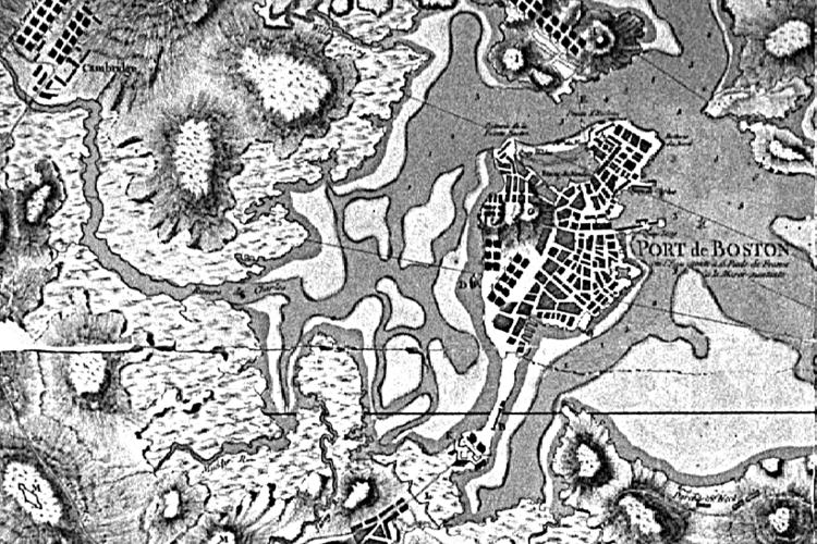
Fig. 1. Boston in 1775. Carte du Porte et Havre de Boston, Chevalier de
Beu_rin (Courtesy Harvard College Library Map Collection).
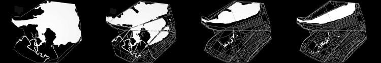
Fig. 2. Back Bay’s evolution over time.
Wild Territory (-1802)
In 1630 Dr. Oliver Wendell Holmes described the marsh landscape of the
Great Bay (as it was called) as an overgrown tangle of windblown trees,
filled with an array of wildlife and "one human."4 It was murky
territory, ambiguous land that was not quite land but not quite water.
Subject to diurnal tides, it literally shifted beneath people's feet,
making it quite undependable. This murky territory was proximally near
the "owned," platted, and bustling territory of central Boston.
Yet, conceptually, it was a world away. In fact, most accounts of it are
'remote'–from somewhere else–reporting it as a place that colonists
liked to view passively.5
The coupling of expansiveness and uncontrolability imprinted Back Bay
as a place of untamed, wild creatures that could only do colonists harm.
Some of those wild creatures were human. It kept French and English troops
literally 'at bay' in their military encampments. Nonetheless in April
1775, the British attempted to capitalize on the Bay's murky, shrouding
qualities when they crossed the Charles River portion of the bay, prompting
Paul Revere's famous cry that "the British are coming."6
The fens’ wild qualities also allowed the marsh landscape to serve
important infrastructural functions. As a shifting landscape that could
not be (literally) settled, it allowed only transitory human inhabitance,
primarily men whose intents were to catch those wild creatures, "the
haunt of duck hunters, [and] fishermen" as well as "mudlarking
boys," children who enjoyed frolicking in the mud.7 For approximately
a century and a half, it served as a version of the increasingly popular
‘urban wilds,’ those remnant landscapes within the city that
maintain access to the city’s former nature, a natural landscape
not filled with human intention.
The marsh’s wildness also bolstered the city's conceptual understanding
of itself. Functioning as a reciprocal to the built city, the fens made
distinct the sense of the city as a 'cultured' entity and not a savage
territory that the British accused it of being.
Productive Landscape (1803-1821)
By 1803 growing land availability pressures of Boston took precedence
over impressions of the land being dangerous territory–at least in
part. Few took up residence in the low lands, but land-poor colonists
began looking for free ways to raise livestock. The Back Bay's marshy
lands, adjacent to the traditional grazing land of Boston Common, made
them obvious choices, particularly once grazing was banished from the
Common. The marsh lands were also obvious choices because they were filled
with salt hay. In such a vast marsh, cows grazed freely without danger
of outcompeting one another and without the need for cattle owners to
own land. When it was time to slaughter, the owners simply went out to
'hunt' them.
The marshes were also valuable hay crops for those whose land was not
large enough to support hay feed for their animals. Citizens need not
own this crop land. They merely needed to load hay on gondolas from the
bay and on carts from landside. And finally, increasing numbers of Bostonians
fished and dug clams for subsistence and for sale at the market.
Therefore, during the early years of the 19th century, the Back Bay landscape
shared oftentimes forgotten values of urban landscapes. It supported productive
citizens in positive ways that not only served them personally but also
served the larger city. The landscape's activities had no direct economic
benefit to the city's official economic tally, what might metaphorically
be likened to a ‘gross national product.’ Nonetheless, the landscape
served the city well by contributing to the city's less official but perhaps
more important ‘gross urban product.’ By supporting the subsistence
of residents, it contributed to Boston's economic stability.8 It was a
productive landscape that did work for the city's developing urbanity.
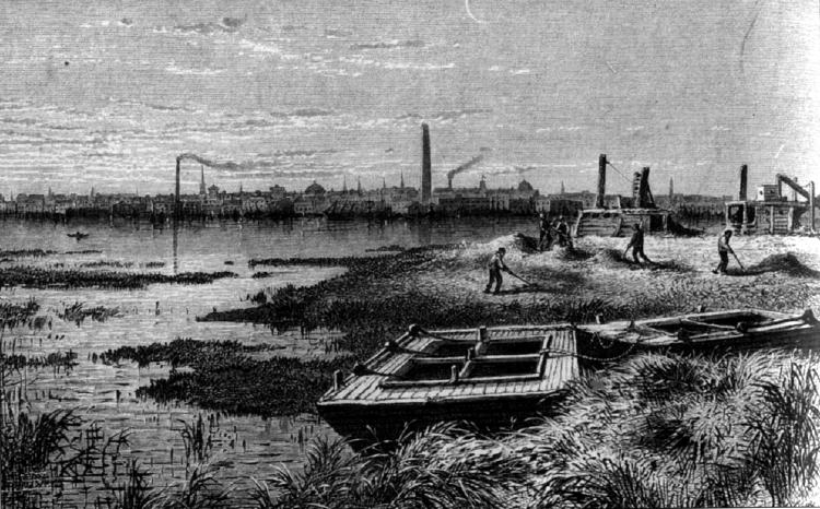
Fig. 3. Salt hay harvesting in the marsh.
Unsanctioned Activities (1821-1849)
The productivity of the fens landscape grew exponentially with the 1813
actions of Uriah Cotting and his business partners when they petitioned
for "liberty to build a Mill Dam."9 The fifty foot wide causeway
was composed of a gravel toll road along the river side and on the bay
side was a plank walk planted with poplars. A short cross dam divided
the bay in two. At high tide water passed through floodgates, moved through
sluices, and generated power as it passed into a receiving Basin. At low
tide, the water drained back through Mill Dam sluices into the Charles
River. The industrial mecca anticipated by Cotting never materialized,
in part because the anticipated tidal energy proved highly overestimated.
The greater reasons were the railroads that came in 1835. The Boston +
Worcester and the Boston + Providence converted the "waste"
land into an important transfer station for goods. Soon the Back Bay was
a bustling industrial complex.
Intentional, physical public access–as opposed to mere visual access–subdued
some of the landscape’s wild associations and brought new infrastructural
possibilities. People began to enjoy being in the marsh. People cut ice
from the shallow marsh waters. The Mill Dam became a fashionable place.
People promenaded. Irish immigrants by the hundreds enjoyed big rigger
boat races from along the Mill Dam.10
Simultaneously, the marsh continued to retain its 'wild' qualities, albeit
subdued, and therefore allowed unsanctioned activities to occur without
retribution. The marsh landscape hosted activities that could not occur
in more codified and behaviorily restricted urban landscapes. And it harbored
urban needs and citizens that the built city could not. Contemporary accounts
report that a walk on the Mill Dam meant that couples could court in the
early evening hours without fearing observation.11 And the Mill Dam's
breadth, length, and straight run made it a favorite place for sleigh
racing, impossible on city streets. Small tipcarts dumped household garbage,
while others hoed through the ashes and took away chairs, bottles, and
other "unconsidered trifles."12 Trash dumping enabled some citizens
to rid themselves of unwanted rubbish while other citizens gathered what
they needed. And finally, the marsh took on a long lasting marginal activity
when in 1827 the city obtained permission to flush sewage into the fen.
Functionally the tides' natural flushing took the waste out to deeper
waters, helping stem the city's cholera outbreaks–at least to a degree.
Urbanistically the fens landscape became an official municipal utility,
a sewage infrastructure.
The fens were no longer a reciprocal landscape to the city. The marshland
had established a median ground, a wonderfully ambiguous landscape infrastructure
that could hold many expressions and serve many urban infrastructure needs.
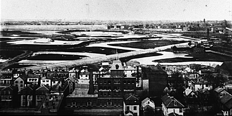
Fig. 4. "Waste" land becoming integrated with the city (Courtesy
Boston Public Library).
Coordinated Infrastructures (1850-1869)
Within ten years of the railroads' coming, the ever increasing quantity
of sewage and the ever decreasing tidal flushing caused citizens to continually
complain of "the abode of filth and disease" from which "every
western wind sends its pestilential exhalations across the entire city."13
Feces rested on these flats at low tide. A simmering public movement for
sewage reform heated to a boil.
The sewage reform issue deserves a more thorough treatment than can be
accommodated here. It suffices to say that the Boston Board of Health
concluded that the "mills were of little profit to anybody and nuisance
to everybody...and that it was desirable to fill the Receiving Basin...and
to convert it into solid land."14 The City negotiated a tripartite
agreement between the Commonwealth, the City, and two corporations. They
developed a plan and began filling land at a frenzied pace. All totaled,
they filled over 800 acres, an unprecedented urban design effort.
Based on Haussmann's and Alphand's Parisian infrastructure efforts, Back
Bay was transformed into a particularly well-orchestrated and unified
collection of infrastructures– an impressive urban design effort:
evenly-distributed, planned streets, orchestrated topography, positive
surface drainage, understandable lot layouts, street trees, a park-like
boulevard, sculpture, and a set of deed restrictions to ensure its 'proper'
development.
The prescriptive urban design came with a social cost. Forty of what John
Charles Olmsted called "the cheapest kind of dwellings" were
condemned. He continued to say that unless some extensive and expensive
improvement of the whole valley were to be soon made, it was seemingly
inevitable that this "squalid and unsanitary occupation of it would
cover all parts of this valley and discourage good occupation of the neighborhood."15
Both turn of the century and contemporary writers have referred to these
citizens pejoratively as "squatters" and their dwellings as
"squalid shacks" and "shanties".16 However, a closer
inspection of period images suggests that the dwellings were merely typical
of most 18th century Americans. These Bostonians, pejoratively called
"marsh people," were ordered out to make way for Boston's new
fashionable and elite neighborhood. Socially and financially more endowed
citizens took the places of the "marsh people" who were financially
unable to remain unless they were able to secure positions in the Back
Bay residents' houses as servants or other service personnel. Randomly
placed wooden houses and vegetable gardens were traded for unified, deed
restriction-bound brownstone walkups and tree lined boulevards. Where
Back Bay had earlier accommodated a variety of activities and social classes,
it was now a unified urban design, as one 1872 visitor nicely summed it
up, " a class environment of an unusually homogenous kind."17
Civic Infrastructure (1869-1882)
The populations of Stony Brook's watershed had increased so dramatically
that the City Board of Health's annual report speculated that "there
is not probably a foot of mud in the river, in the basins...that is not
fouled with sewage."18 In heavy rains sewers backed up into residents’
houses. Plus, the openness of the vast bay, much loved by many Bostonians,
was quickly becoming filled with four and five story buildings that threatened
to obliterate the city's intimate relationship with the natural landscape.
In 1869 prominent citizens and business people petitioned Boston City
Council to take lands to preserve unbuilt landscapes within the city by
making them parks. The desire for maintaining open space and solving the
sewage problem coalesced into a unique synthetic infrastructure solution
for its time, a stormwater park, a public landscape infrastructure concerned
with aesthetics that also provided important municipal services–flood
control and a kind of sewage ‘treatment.’
The City of Boston hired Frederick Law Olmsted to design Back Bay Park
(later to become the Back Bay Fens) to fulfill its unique specifications
for a park (which would have been linked to stormwater no matter who designed
it). As others have argued, Olmsted designed "ecologically"
by reconstructing the biotically degraded fen. But more importantly, Olmsted
wanted to maintain the full aesthetic, the complete sensibility of the
former fens landscape–its expansiveness, the waving of the marsh
grasses, the blustery winds, the tidal flux. His landscape embraced citizens'
memories as well as the site's ecological memory. The design was no mimic
of the historical landscape. It was clearly transformed into a contemporary
urban expression. What Olmsted delivered was a landscape rooted in the
history of the city and its collective memory.
It was not a cultured park aesthetic of the 19th century elite. Rather,
it was a ‘common’ one, an ordinary landscape of flat land and
marsh-like plantings. It was a landscape valued by 200 years of ordinary
citizens. As such Olmsted chose an aesthetic expression that enhanced
the project's ‘urbanity,’ a landscape design that is meaningful
to all residents, regardless of social class, and a design that contributed
to citizens’ understandings of the entire city.

Fig. 5. Transformation of ecological memory into urban expression (Courtesy
Olmsted National Historic Site).
Municipal Utility (1888-1901)
Because of the creative conjoining of park and stormwater utility, the
Fens functioned as everyone had intended. Stony Brook was encased in two,
9' rubble stone tunnels; the brook was then diverted through a gatehouse
just as it reached the Fens and channeled into a 7' brick bypass conduit
that released it into the Charles River. The Muddy River’s dry weather
flow supplied the Fens’ water; but in heavy rains, a gate valve allowed
it to be diverted through its own bypass tunnel to the Charles River.
Thus, only diluted sewage entered the Fens, and the Fens effectively functioned
as a storage basin for stormwater for the Back Bay area. But the city
grew, and soon the Fens was overwhelmed with sewage. Consequently, the
city built the Commissioners Channel, a new channel and new bypass channel
that would avert sewage being discharged into the park.
The problem was that the city constructed the Commissioners Channel before
constructing its link to the bypass channel. Raw daily sewage flowed into
the Fens for two years until it was diverted to the Stony Brook bypass
conduit in December 1889. Plus the Fens was used on numerous occasions
as a temporary holding tank for dewatering sewage- and deposition-laden
portions of the marsh that were being filled for development.
So distasteful were the conditions that the boats introduced in 1896 were
not-surprisingly removed in 1901 because of "lack of patronage,"19
a sentiment echoed in accounts of people avoiding the park. By 1901 the
Fens was transformed from being primarily a park landscape that also functioned
as flood prevention to being a municipal sewage landscape that hardly
functioned as a park.
It is true that the city chose a plan of action that would allow the Commisioners'
Channel to remain unfinished for eight years. It is also true that the
city chose to intentionally tarnish what had been a very expensive public
landscape works, 85 million in today’s dollars. Yet, these actions
reinforced the landscape’s ability to accommodate perhaps its most
marginal infrastructure, sewage. And at least for a time, it helped citizens
better understand the workings of the city—in all their aspects both
pleasant and putrid.
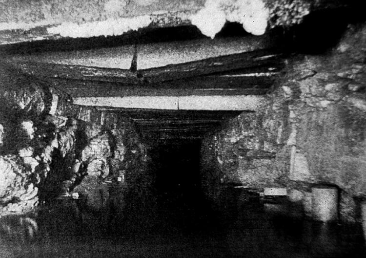
Fig. 6. Conduit beneath Back Bay Fens for sewage and storm waters.
Institutional Magnet (1901-1928)
Once a clear solution for the sewage problem was defined, the Back Bay
Fens became a magnet for a number of prestigious corporations that then
occupied its periphery: Massachusetts Historical Society, Isabella Stewart
Gardner Museum, Simmons College, Emmanuel College, Wheelock College, and
Forsyth Dental Clinic. 20 The two most notable were Boston Museum of Fine
Arts and Harvard Medical School both of which successfully lobbied the
city to redesign the park so that their buildings were "in closer
relation with the Fens."21 To be a part of the Fens was an asset.
Thus, park and institutions were conjoined.
So conjoined were they that residents and administrators began to complain
of the Fens' "misshapen," "ruined," and "overcrowded"
trees that (according to Olmsted, Sr.’s stepson John Charles Olmsted)
were not appropriate among $100,000 buildings.22 The Parks Department
began to replace Olmsted's semi-native, marsh-like choices to those more
likely found in traditional gardens and tidy up the waterway's scruffy
edges. And once the dam was constructed on the Charles River, the Fens
was no longer tidal, prompting administrators and designers to completely
realign the Muddy River, the water course that structured the Fens.
As partner to the institutions, the Fens still fulfilled desires and activities
specific to parks. But to some degree, it was relegated to being a mere
foreground to the institutions, a stage setting for the institutions that
comprised the main events. The Fens began to operate less as a field of
conceptual substance in its own right and more as null ground–open
space–into which other things were inserted.
One of those things was a series of active recreational fields. And another
of those things was garbage. In essence, the city accomplished its recreational
infrastructure goals through another urban infrastructure–landfilling.
The marshes were filled with excavated material from various subway construction
projects, a combination of coal and wood burning ashes, common city garbage,
and "old boilers, bricks, and up-rooted plumbing,"23 Just as
it had in the 18th c., the park served the larger city by providing a
place for it to cheaply dispose of unwanted excavation material, ashes,
and rubbish. A highly visible, upscale urban infrastructure of a park
simultaneously fulfilled a marginal infrastructure need of waste disposal.
Grounds for Collective Civic Expression (1929-1950)
In 1929 Bostonians quit filling the Fens with garbage and instead began
filling it with expressions of civic ideals. The first of these expressions
was the Fens Rose Garden. Its archways and brocade treatment so expressive
of the city's valuing of public gardens that it was more than doubled
to its present size three years later. The Victory Gardens site was a
playfield until WWII when the federal government launched a campaign supposedly
aimed at stemming a potential food shortage and investing people personally
in the war effort. The result was Boston’s expression of its patriotism
in the form of the Victory Gardens much as we know them today. Boston’s
more codified war memorials took form in the 1949 polished granite monument
that remains today. Citizens have continued to add monuments since: the
Korean War and the Vietnam War (1989); the Temple Bell (a peace offering
from Japan); monuments to sports heroes like Roberto Clemente; and famous
citizens like John Everett (a pilgrim forefather) and Katherine Bates
(writer of the poem that became the revered alternative American anthem
"America the Beautiful").
The point is that originally the Fens' primary aesthetic vision was of
one man, Olmsted. Yet, once his vision was literally overturned in the
earth, the Fens became a ground for a collection of civic expressions,
a place for Bostonians to display a series of values that the city as
a whole understood about itself.
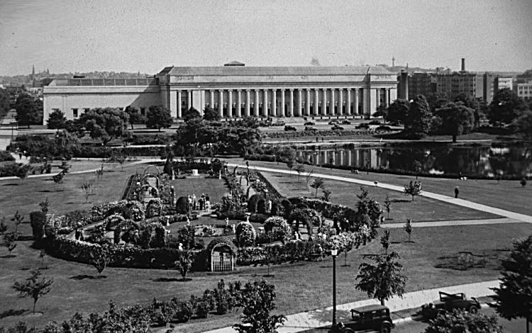
Fig. 7. Rose Memorial Garden foregrounding Boston’s Museum of Fine
Arts (Courtesy Boston Public Library).
Displaced Landscape (1950-1982)
By the1950s the larger Back Bay area was an eclectic collection, too.
It included hospitals, movie theaters, concert halls, music conservatories,
women's colleges, religious colleges, art museums, historical societies,
and corporate 'institutions' like the Seagram Company and Fenway Park.
The businesses and residents were just as diverse. Leonard Bernstein lived
among hardware store owners, and soon-to-be famous artists lived near
prostitutes.
But in the1960s many of the same institutions threatened the healthy diversity.
The economic dynamics are fascinating but too complex to thoroughly examine
here. Suffice it to say that the burgeoning of tax exempt institutions,
large scale urban renewal efforts in the name of ‘progress,’
and a nationwide exodus to the suburbs caused Back Bay to lose much of
its middle class, an important stabilizing force for the neighborhood
and caretaker group for the park.
The result was the influx of new populations. Those without the money
to patronize drinking establishments turned to the Fens as their outdoor
bar. One cleanup effort resulted in the collection of ten thousand beer
cans, but this reportedly did "not even scratch the surface."24
Plus, lack of maintenance allowed homeless people to 'construct' dwellings
within overgrown shrubberies and inhabit unkempt, unused buildings like
the Clemente field house.
Phragmites, an aggressive dense-growing reed, was introduced in the Fens
sometime in the 1950s or 1960s to provide a nesting area for ducks. By
the 70s it was so visually impermeable that it provided a habitat of sorts
for a new displaced group–homosexual men. Since then gay men have
cruised the Fens looking for companions. Some men are looking for very
short term relationships, which occur in the phragmites, which is 25’
high and 30’ deep along parts of the Fens waterway. The vegetation
is so dense that the Fens now has a complex of 'sex rooms.' Many of these
men are married or others who do not want to reveal their homosexuality.
The landscape provides an opportunity for men to show themselves locally
yet cloak themselves from the rest of society—a precarious yet functional
balance. 25
Olmsted had always meant for the Fens to be a place of "persons brought
closely together, poor and rich, young and old, Jew and Gentile."
26 He got more than his wish in the 70s when the Fens provided some groups
a sort of refuge from the social mores of the majority. As a social infrastructure,
it offered the city a landscape for those who did not have another place
within the city.
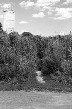
Fig. 8. ‘Sex Rooms’ in the Back Bay Fens.
Repository of History (1983-1996)
Back Bay mounted a recovery in the 1980s. 'Recovery' was a key concept
for a park that was in such a degraded state. Bridges, walks, and buildings
were literally crumbling. Vegetation was overgrown and noticeably untrimmed.
Much of the original diversity had been lost, particularly the understory
trees and shrubs. Volunteer and invasive plant species confused the park's
aesthetic. And drainage was uncontrolled.
Sparked by a resurgent interest in landscape history and in Olmsted himself,
the plan helped garner a constituency which spurred the State Legislature
in 1983 to call for "the preparation of plans...and for the rehabilitation
and restoration of the Olmsted parks in the Commonwealth," including
the Back Bay Fens.27 And the position of restoration is still the strategy
in effect, best described by Pressley Associates/Walmsley Associates'
1983 plan, in which they propose that the Fens' strategy be one of "Adaptive
Restoration... the accommodation of new [post-Olmstedian] uses while preserving
the "look" of the original scenic composition."28 Apparently,
the Fens is a valuable infrastructure as a historical repository of many
times and values and expressions–a pastiche of the city’s history.
Making Cities
With this plan still operating as a conceptual guide, the Fens has steadily
been improved since the 80s. But its pivotal moment is now. Together active
citizens groups, the Parks Department, Boston Water and Sewer Authority,
and other municipal authorities have landed a $19 million+ coup and secured
approval for the Fens to be dredged and its banks regraded. With this
effort, Bostonians have the chance to exercise urban design in ways that
we should perhaps all be exercising.
The Back Bay Fens demonstrates how expanding public landscapes’ roles
can accommodate the increasing diversity of urban populations. It has
continually accommodated–even nurtured–citizens, activities,
and social conditions that have been unwelcomed and shunned by more codified
and restrictive built landscapes: becoming recycling territories; housing
those without property; offering workplaces and food sources for those
without conventional employment; sheltering homeless displaced by more
restrictive politics; providing cover for socially shunned citizens; accommodating
a diverse population not as actively fostered elsewhere in the city; and
providing a welcomed territory for typically disdained municipal infrastructures
like sewage treatment, stormwater control, and landfilling. And only in
rare moments has accommodating these marginal roles disallowed or diminished
more codified activities and populations that are accepted anywhere in
the city.
The Back Bay Fens also demonstrates how built natural infrastructures
can further citizens’ understandings of the city: the municipal services
and urban processes that make it work; the values it holds collectively;
the relationship of those collective values to those that are outside
mainstream mores; and the range of relationships to nature from contrast
to it to foreground for it. To find these creative intersections expands
not only the city’s aesthetic expressions but also provides more
forums for citizens to exercise more aspects of their citizenship.
And finally the Back Bay Fens also demonstrates how landscapes, as marvelously
amphibious structures, landscapes able to transform themselves into new
structure that serve the city's changing needs. The Fens' evolution demonstrates
the value of shifting our view of designed urban landscapes from being
static infrastructures conceived at a singular moment to being dynamic
urban structures that can continue to be active agents in the city.
Were the city to value the Fens’ legacy of continually providing
a place for that which the city rarely gives place, it might allow one
of the Fens’ most important histories to resonate into its future.
Were the city to ensure that the Fens’ future designs continue to
enrich citizens’ understandings, it might continue to offer creative
models of urban design. Were the city to value the Back Bay Fens’
ability to continually evolve, it would demonstrate what all urban landscapes,
as infrastructures, have the opportunity to accomplish: to define urban
territories in which all citizens might shape the city of their imaginations
and the city they wish it to become.For a full-color, multimedia presentation
of the image accompanying this essay, contact the author at kpoole@virginia.edu
for access to the larger Back Bay Fens project website, currently under
construction
.NOTES
1 For a more complete historical account and discussion of the Back Bay
Fens’ infrastructural roles, look for the author’s article forthcoming
in Landscape Journal.
2 The essay builds upon the important work of my predecessors, in particular,
Cynthia Zaitzevsky, Anne Whiston Spirn, and Catherine Howett. What distinguishes
the essay is its departure from their consideration of the Fens as an
infrastructure at singular moments in time, either when Olmsted originally
designed it and/or in the present day.
3By definition, a fen is a peat-accumulating
wetland that receives some drainage from surrounding mineral soil and
usually supports marshlike vegetation.
4 Howe, 1.
5 Barbara W. Moore and Gail Weesner,
Back Bay: a Living Portrait (Boston: Century Hill Press, 1995), p. 8.
6 Ibid.
7 Ibid.
8 Many thanks to Camille Wells, who in
her usual collegial manner, helped a hunch take historical form.
9 Arthur Muir Whitehill, Topographical
History of Boston, p. 100.
10 Oscar Handlin, Boston’s Immigrants
1790-1880: a Study in Acculturation (Cambridge: Belknap Press of Harvard
University Press, 1959), p. 157.
11 Whitehill, op. cit., p. 101.
12 Whitehill, op. cit., p. 32.
13 Moore and Weesner, op cit., p. 11.
14 Moses King, The Back Bay District
and the Vendome (Boston: Moses King, 1880), p. 5.
15 John Charles Olmsted's comment is
found in his "Perambulatory Tour" with Arthur Shurtleff in A.
A. Shurtleff. October 7, 1910. Notes On Perambulatory Trip Through the
Park System With Mr.Olmsted and Mr. Pettigrew.
16 John Freeman refers to them as "squalid
shacks" in John Freeman, Report of the Committee on Charles River
Dam (Boston: Wright & Potter Printing Co., 1903), p. 195. Weesner
refers to them as "shanties," op. cit.
17 John Brinckerhoff Jackson, American
Space: the Centennial Years 1865-1876 (New York: W. W. Norton & Company,
Inc., 1972), p. 128.
18 Main Drainage, pp. 19-20.
19 Moore and Weesner, op. cit., p.8.
20 In part the Fens was riding on the
coattails of Back Bay, as the district had always been planned as a district
for prestigious institutions. Yet, these corporate entities made clear
choices to locate directly adjacent to the Fens and to orient their structures
to take best advantage of it.
21 30th Annual Report of The Board of
Commissioners for the Year Ending January 31, 1905. Boston Parks Commission.,
p. 7.
22 Shurtleff, op. cit., pp. 14-15.
23 The Fenway. Boston 200 Neighborhood
History Series (The Boston 200 Corporation, 1976).
24 Record American. Friday, July 10,
1970. Text by David Rosen, Photos by Earl Ostroff and Richard Chase.
25 The balance is precarious because
that same cloaking makes the Fens a landscape of fear. Numerous muggings
and hate crimes have been leveled against queer couples and individuals
in the Fens. The landscape that allowed a community to develop also makes
it a dangerous one.
26 Frederick Law Olmsted. Parks and the
Enlargement of Towns.
27 Pressley Associates/Walmsley Associates,
The Emerald Necklace Plan for Restoration. (Boston, 1983).
28Walmsely/Pressley Joint Venture. 1989.
Emerald Necklace Parks Master Plan. Prepared for the Department of Environmental
Management, Homestead Historic Preservation Program.
|