9. Use
9.1. Use of panoramas and VR in the lecture/classroom/lab/home
The great advantage of using panoramas of buildings in the classroom is that they can replicate the actual experience of being in a space. Students become interested in the spatial experience of the building to a much greater degree, so much so that gasps from the audience often mark the first use of digital panoramas in a class. Students who have never visited Charlottesville find themselves at the center of Mr. Jefferson’s Lawn, able to look around them as if they were actually standing there. One caveat is that the instructor (or whoever is navigating) must learn to move the image slowly and steadily, however, so that the class doesn’t get simulator sickness. If a quick movement is necessary, the lecturer should warn the audience.
The images themselves allow the instructor to skip much of the contextual explanation required when showing slides, since the information is available on screen. On the other hand, because movement through the building must be slow for the sake of the viewers, instructors may find themselves covering fewer buildings per class. Cutting down on examples is not necessarily a bad thing, particularly in introductory courses and when buildings and objects can be presented in compelling ways. The technology works particularly well for rotating the object and showing sculptures in the round. For sculpture attached to buildings, such as Vézelay or Chartres, panoramas can demonstrate the relationship between the sculpture and the building, and show architecture in a most revealing way. Audio features can make the acoustical properties of a structure apparent. For example, the abbey church at Neresheim has a nine-second delay that can be experienced through a recording of the organ and chanting monks.
Alternatively, panoramas can be used for independent study. Students who have used digital panoramas on their own computers report that panoramas make it possible to comprehend the totality of a structure, which helps tremendously in studying individual buildings. Instructors might assign the study of particular panoramas for paper topics or for prepared exam questions. Even a building as complex as Rem Koolhaas’s Central Library in Seattle can be mastered from panoramas, as long as the panoramas are accompanied by clear diagrams of the structural systems.
The principal drawback is that the instructor can have only one image on the screen at a time. The simplest way around this is to use panoramas together with slides projected on the same screen or wall. For example, to explain the promenade through the Bibliothèque Ste. Gêneviève, the instructor might show a slide of the plans of all three floors on the wall next to the digital views of the outside and inside. Supplementary slides can also incorporate comparative or historical material into the lecture. If the classroom has two digital projectors, the instructor can project a panorama and a PowerPoint summary at the same time. Regardless, the instructor should supplement panoramas with other kinds of simultaneous projection. Digital panoramas should not replace traditional slide presentations but add depth and interest to them.
Any new technology takes time to master and it would be wise to practice with dry runs and workshops before debuting it in the classroom. Plot the course of the movement through the space, coordinate the accompanying slides, and then run through the lecture several times before going public. It is also wise to plan ahead for technical problems: back-up the panorama on a CD or DVD and bring it to class, especially if data is being accessed via the internet. If several buildings are being discussed in one lecture, set them up ahead of time so that the presentation can go smoothly from one building to the next.
9.2. Scholarly use
Many of the reasons for using panoramas in scholarly work are the same as those for classroom use. First and foremost among these is that digital panoramic photography provides a more accurate sense of space than 2D images. This provides a sense of immediacy and replicates the seamlessness of seeing the actual space or object. It also facilitates research into spatial relationships in individual buildings or sites, making these relationships apparent in a way that flat images or even site visits may not. John Dobbins, Art History professor at the University of Virginia, notes that using a 360° panoramic image of Pompeii allows him to analyze a complex intersection between the forum and the areas of the city that lie beyond it. Rather than relying on a series of fragmented still photographs, he can move smoothly through the site to understand the overall relationship in all of its complexity. Unlike videos, where the videographer controls the image, the digital panorama user has total control over the movement and speed of the image, although restricted by the position of nodes.
In addition to the spatial component, contextual relationships, larger scale studies, and collaborative work all benefit from this technology. Dietrich Neumann, Art History professor at Brown University, has said that digital panoramas were invaluable in his study of the relationship between the lighting programs of the Wrigley Building and Tribune Tower. Through the use of panoramic images of Chicago, he can study and demonstrate the correspondence between the lighting programs of the two buildings. In some cases, the high resolution and accuracy of the images brings out details of building sequence, materials and chronology that are actually less apparent on site.
The digital nature of the information allows collaborators to consult across long distances on their projects while viewing the same material with the inherent advantages of digital panoramas. The disjointed nature of separate photographs laid out in a mosaic is avoided as collaborators digitally coordinate movement through the space and around the site while discussing their ongoing investigation. Constructive and productive use of this technology facilitates exploration of new questions in architectural history as well as more effective analysis of traditional issues.
9.3. Practical use for engineers and architects
Photometrics from digital images
All digital images are gridded images produced by rows of pixels arranged
in x and y alignment. By using a known measurement, such as the length
of a brick, it is possible to assign pixel value to this known measurement.
Once the pixel/brick ratio is established, the pixels per foot is easily
determined and one can take measurements from any flat surface. Caution:
The image plane of the camera must be kept perpendicular to the surface.

Figure 1. M & T Bank Building, photographed with large-format camera
equipped with scanning system. Click picture to enlarge. Photo by Tom
Watson.
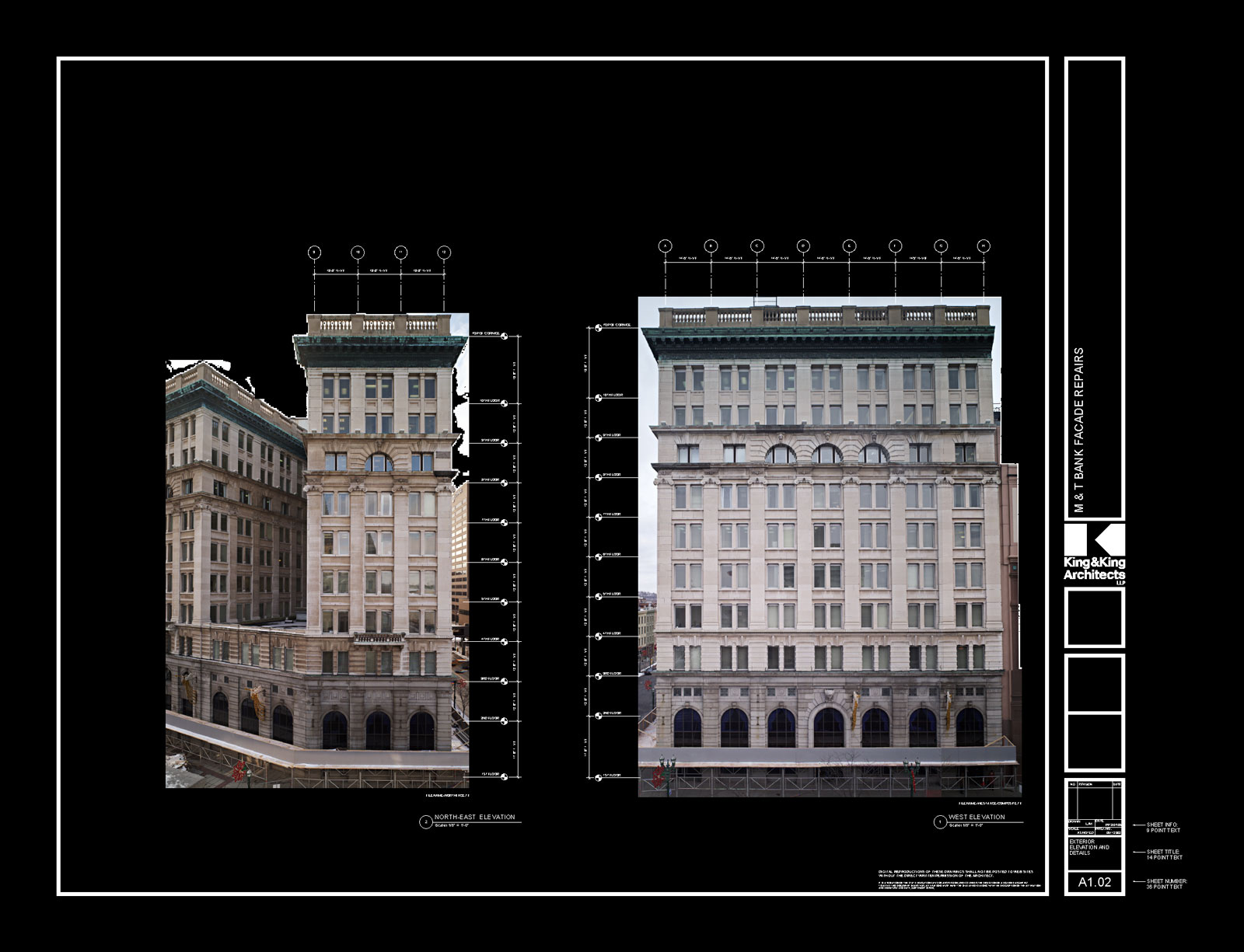
Figure 2. M & T Bank Building in AutoCAD. Click picture to enlarge.
Photo by Tom Watson.
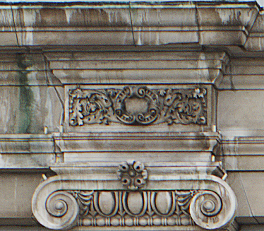
Figure 3. Detail of M & T Bank Building photo shown in Figure 1. Photo
by Tom Watson.
Tom Watson's image files of the 100-year-old M & T Bank Building (Fig. 1-3) were loaded into AutoCAD. The images replaced the usual line drawings generated by laborious manual methods and all masonry surveying engineering and dimensioning were taken from the image files.
Software
The ability to make pixel measurements is a property of simple software
such as Photoshop
and more powerful programs such as AutoCAD.
Hardware
Any digital camera will produce a file suitable for measurement. However,
image resolution is directly related to usefulness as a measurement tool.
If the goal is to see small details (high resolution images) are powerful
analytical tools.
Photometrics
Panoscan recently introduced new software, PanoMetric,
which allows measurement of a panorama image (photometrics). This method
uses a stereo panoramic image with a precise distance between image centers,
that is processed in panometric software to allow the user to make measurements
within the panorama.
9.4. Internet
The internet is a wonderful tool for distributing virtual tour and multimedia projects to specific communities on campus or across the globe. With ever-increasing bandwidth and faster, less expensive computers available, it is possible to do things today that even five years ago would have required specialized hardware and would have been the purview of the technological elite. The data transfer barriers of yesterday are quickly being eliminated, particularly on local, ultra high-speed optical fiber networks regularly found on academic campuses. New panoramas are posted regularly, on specialist sites such as panoramas.dk and on general interest sites such as YouTube. There is enormous creativity and inspiration on display, in both subject matter and presentation of information.
It is easy to create multiple versions of a digital panorama with varying resolutions and file size, so that users can choose the version of the project that best matches their computer speed and Internet connection. Note that for internet distribution it is important to provide the basic contextual information about the subject being shown in the images. Data documentation and metadata is discussed in section 7.
9.5. Publications
As digital photography technology improves and the quality of digital panoramas increases, the general public is becoming more familiar with them. We are beginning to see this technology permeating the world of publishing. Textbooks are beginning to be sold with DVD-ROM supplements and dedicated websites that provide digital images that are greatly enhancing the student’s learning experience. These new tools often provide high-resolution zoomable images, usually more than are available on the printed pages, as well as digital panoramas. An accompanying website provides a place where the publisher can provide new information and corrections. A DVD supplement can provide full-resolution panoramas as well as the necessary viewing software. Some publishers and on-line archives provide software that allow scholars to use digital images to create PowerPoint-like presentations, similar to the way slide libraries work in conjunction with lectures. As time goes on, the prevalence of digital images and panoramas in the academic world will only increase, opening a world of possibilities for educator and scholars alike.
9.6. Hand-held device at site/landscapes
In the future it may be possible to use a hand-held device at an archaeological site or landscape that, using GPS technology, will be able to provide a computer-generated view of how it looked at certain points in time. This would be a modern version of the Then and Now series of books that a visitor can purchase at an archaeological site like the Roman Forum.
9.7. Historical and heritage site preservation and restoration
Besides being a useful tool for scholars, educators, and students, high-quality high-resolution digital panoramas serve as an important historical documentation of a site that provides a relatively objective 360° view — a record of how a place looked at a certain point in time. The importance and uniqueness of this type of documentation is exemplified in two separate projects.
- Brian Donovan’s documentation of the Orthodox monastery of Hilandar at Mount Athos in Greece. The monastery suffered a devastating fire in 2004 that destroyed about sixty per cent of the monastic complex, and Donovan's work is a unique record of much of what was lost. (See Donovan’s account in section 2.8.)
- The Mellon International Dunhuang Archive, undertaken by a team from Northwestern University, in collaboration with the Dunhuang Research Academy (China). Members of the team photographed wall paintings and grottos in dozens of Buddhist cave grottos along the Silk Route in the Gobi Desert. They then stitched the images together to create 2D and 3D representations of the cave walls. Parts of the walls of the cave grottos supporting the mural paintings have since fallen down, and while these panoramic photography campaigns do not represent the only images of how these sites once were, they do offer unique views that provide intricate detail, often difficult to see in situ, now impossible to visit and see in person.