

Vinegar Hill: A Brief Urban History (1)
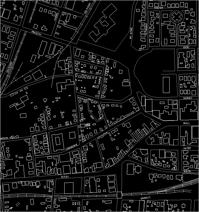
In the most strict interpretation, Vinegar Hill refers to the segment of West Main Street as it moves from Second Street, SW up to Fourth Street. Early in the nineteenth century, this portion of Main Street also acquired the name of Random Row in recognition of the way that the street deviates from the regular grid of the original town plan. The gentle curve of the street, combined with a rather steep incline produced a series of stepping and mostly detached structures along both sides of the street. As James Alexander recounts in his Recollections of 1874:
"Random Row commences at the end of the old town boundary, and once was a part of the farm of Joseph Bishop, who built the brick house now occupied by J.J. Utz, which house is said to be the oldest brick structure in the town' there were in 1828 several fine brick edifices in this row or street, and are standing at this day. This portion of our town was not added to the corporation till after 1835...."2
Most interpretations would suggest that the triangular area defined by Main Street on the South, Preston Avenue on the north and Fourth Street on the west constitutes the Vinegar Hill area, immediately to the west of the original downtown grid of Charlottesville. Stories and accounts from the nineteenth century and early twentieth century are ambiguous in explaining the origination of the name for this neighborhood. James Alexander, reflecting back to the early part of the century, recounts the reputation of the area as a center for moonshining in Charlottesville:
"Here properly ends Random Row, called by many 'Vinegar Hill'. The first name was probably obtained from the random way the houses were put up, without reference to the old town lines; at the head of the hill the street is much narrower than at its foot. Mr. J. Frank Fry tells us that the name 'Vinegar Hill' was given to it on account of the illicit trade carried on in the sale of distilled liquors by persons doing business as grocers' they labeled the casks containing spirits, 'Vinegar'. We have often heard this street called purgatory, as it was a very bad road to travel, rough, rocky and steep; accidents to carriages and vehicles often occurring. Since the street became a part of the town, the authorities have graded and macadamised it, and now it is in as good condition as the rest of our streets."3
Alexander goes on to indicate another interpretation of the name's origin, relating to the old Irish fighting song by the same name:
"....and this brings us back to the foot of the hill, and the beginning of Random Row, or "Vinegar Hill". The latter name we have since been informed, was given to it by George Toole, and he named it in honor of the Vinegar Hill in Ireland, where the O'Toole's lived, an account of which can be seen in Lever's novel of Charles O'Malley, The Irish Dragoon."4
Many of the early residents of this neighborhood were Irish immigrants, several hundred of whom moved into town with the rail construction crews around 1850. There were several drinking establishments along Main Street, and apparently fights were quite common. Mary Rawlings indicates in her footnotes to the Alexander Recollections;
"Under the stimulus of sufficient conviviality, one part would ally forth to 'clean out' the other. The old Irish fighting song of 'Vinegar Hill' would be raised and adherents would flock to both standards. Where the Lewis and Clark monument now is situated was an open space with town pump and trough which furnished the battle ground, the vanquished being finally ducked in the trough and rolled in the mud. There was a saying that the O'Tooles, the O'Tracys and the O'Donovans ruled Vinegar Hill......We are told that the older dwellers on this street insisted that the proper name was 'the Hill', and considered the later name (Vinegar Hill) a nickname."5
Rawlings also identifies the possible role of at least one tannery that was located at the base of the hill; the foul smells of this operation could have also contributed to the name for the area. Apparently water played a prominent role in the identity of this area. Several springs existed toward the top of the hill, and many of the houses in the area had their own wells. Water flowed freely in a drainage pattern that moved directly through the neighborhood. In John Hammond Moore's book on Albemarle County, he cites a moving account of the area from an editorial entitled "Art and Nature in Town" dated June 22, 1860 in the Review:
"(the editorial) rhapsodized over the spectacular sights to me seen. 'We have in our midst one of the wildest and most romantic chasms in the mountains of Virginia. Indeed Charlottesville combines to a greater degree than any village we know the diverse attractions of city and country.' Describing in glowing detail perils and vistas to be encountered as one walked along a ravine carrying water from the Vinegar Hill area to Wills's Ice Pond in what is now the 200 block of Preston Avenue, the editors continued, 'Like the traveler over some Alpine pass, the danger will add to the vividness of his feelings. The best time to go is on your way to evening service at the Episcopal Church - when the moon is over spread by some black cloud. One inch to the right will break both legs, and if the torrent is up, sweep you romantically under the planks and under the fence - 'down to the endless seas'. We do not know who designed this. It is greatly superior to the Serpentine in London, or those artificial cascades in the Bois de Boulogne. It was a good thought, to have a real ravine amid the hum of a city, and when after a rain the water comes thundering down, the view is sublime ... It was left to the giants of an inland town in Virginia to develop the idea of a civic ravine - a mountain gorge amid the populous haunts and the confined air of a busy municipality.'"6
During the Civil War, Midway Hospital was built at the intersection of Main Street and Old Lynchburg Road (Ridge Street) atop Vinegar Hill. The hospital served as one of three facilities supporting the Confederate effort. Between 1861 and 1865, over 20,000 soldiers were ministered by these hospitals.
In 1893, the Midway School was built on the site of the former hospital. Around the turn of the century, nearly 1500 students were enrolled at Midway (all local white students). Black students were enrolled exclusively at Jefferson School, on the western edge of the Vinegar Hill neighborhood (Commerce and Fourth Streets). By 1925 three more schools were added within the city (McGuffy-1916, Venable-1925 and Clark-1931) but these were grade schools for white students only. Approximately 250 black students were enrolled at Jefferson, but the school continued only through eighth grade . In 1926 Jefferson was enlarged to accommodate the black students who wished to continue their high school education; before this date, any interested students had to leave town beyond the eighth grade.
Throughout the early part of the twentieth century, Vinegar Hill emerged as an important center of commerce for the black community of Charlottesville. Sanborn maps clearly indicate a wide range of small scale industrial and service businesses that were located in this area. In addition, many small detached homes and at least three churches occupied the irregular sites between Main Street and Preston Avenue. Several recollections were included from City of Charlottesville's oral history project of the mid 1980s. From Porch Swings to Patios7 includes several revealing accounts. Each of these individuals touch on some aspect of life around West Main Street or in the Vinegar Hill neighborhood: Ella Baylor, George Ferguson, Thomas Ferguson Inge, Sr., Rebecca McGinness. These accounts identify the segregation that was a fundamental fact of life in small southern towns. It is within this context that one must understand the jarring effects of school desegregation following the Supreme Court decision of Brown vs. Board of Education in 1954. Under segregationist governors, communities within the Commonwealth of Virginia fought the federal imperative of desegregation.8 The "battle" surrounding this issue had a particular impact on the Vinegar Hill neighborhood, because the white high school had been built at the base of the Hill on Preston Avenue, while black students remained in separate facilities at Jefferson School and elsewhere in the city. The process of "urban renewal" in the 1960's directly paralleled the fight to avoid integration by city leaders.
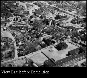
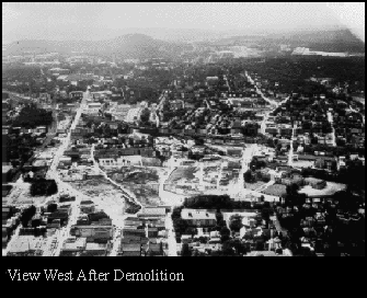
Vinegar Hill was largely demolished in the mid-1960's as a part of Charlottesville's "urban renewal" campaign. The political forces within the city saw a derelict slum that had developed on the hillside immediately adjoining the downtown district. At the same time, peripheral areas beyond downtown had begun to draw commerce away from the central district and some form of revitalization was seen as necessary to staunch the flow. In addition, there was no smooth north-south connection through the downtown area of Charlottesville, and ease of automobile and bus transportation was seen as a high priority, especially for the Greyhound franchise which stood at the top of Vinegar Hill on Main Street. All of these factors combined with available federal money and a very thinly disguised racist agenda of slum clearing in an area so close to the reputable downtown business district to produce the nearly wholesale destruction of a neighborhood that was uncommonly rich in its own heritage, traditions and lore within Charlottesville.

| 
|
The elimination of the principal area of commerce for the African-American population of Charlottesville , in close proximity to the city high school, cannot be seen in isolation. While the community only temporarily succeeded in avoiding integration, the destruction of Vinegar Hill has had a profound and long lasting effect on the identity and economic health of a formerly cohesive neighborhood. As early as 1976, John Hammond Moore identified some of the many shortcomings of such a violent urban act:
"The Hill, now swept bare by an urban renewal scheme which seems to have faltered, then had forty-one buildings on the north side of the street and sixteen on the south..... Vinegar Hill did not burn down nor did all the "bad folks" disappear when that sordid but colorful jumble of buildings was razed. Center of bootleg activity and vice it was, but the hill most assuredly was much more vibrant and alive in its former guise than it is today, now merely an expanse of bare ground stretching like a no-man's-land, perhaps to be the site of the downtown business district's last stand should the upstart shopping centers mushrooming a few miles to the west ever launch an all-out attack"9
The hope of an area, cleared of unhygienic slums, miraculously evolving into a vibrant component of a revitalized downtown district has not been realized. Urbanistically, the area has followed a number of planning and architectural formulas from the 1950's and 60's. These involve the primacy of the automobile in its smooth operation at fairly high speeds through the city, serviced and supported by ample areas of grade parking, in which an occasional building is placed. As a strategy, this is in direct contrast to the fundamental relationship that existed in this area between building and street, between a clearly discernible front versus back of each property, between the amenities and social support of the public realm.
It would be impossible to resurrect Vinegar Hill in its earlier form, and few would be interested in the problems of drainage and the absence of sewer hookups and running water that many of the properties had to endure. However, some form of reconstruction can be imagined, and one hopes that this new interest in the area can seriously consider the rich history of the place and the memory of its former residents.
| Vinegar Hill Notes | Vinegar Hill Photograph Archive | Charlottesville Bibliography |
| Bibliography | Make a suggestion |
 IATH WWW
Server