|
|
||||||||||||||||||||||||||||||||||||||||||||||||||||||||||||||||
|
Gigi Saltonstall • Immersion |
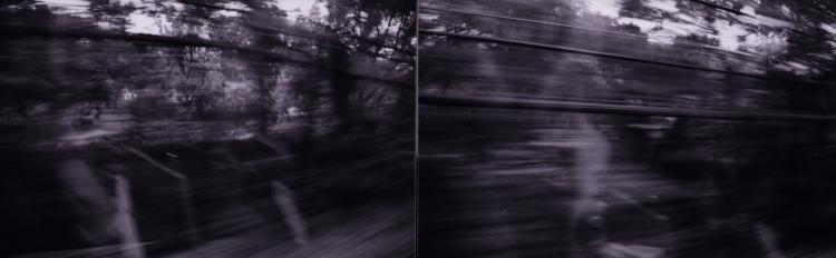
Since the Fens is commonly experienced from multiple modes of transportation, the intention of this exercise was to document the Fens from some of these varied modes. The Fens is most often visually documented by people on foot, but the edge especially is constantly viewed by those in cars and on the "T". Two trips on the "T" were documented, one on the "D" line as it emerges from under Kenmore Square and the other on the "E" line as it passes Northeastern University and the MFA with the Fens in the background. From the "D" line, the Fens is a blur of trees with occasional views of the Muddy River. After the train surfaces, it quickly comes upon this extent of green, offering a moment of relief to the cramped travelers. From the "E" line, the Fens acts as a backdrop to the large institutions and bustling life along Huntington Avenue. It is revealed only in pieces, literal snapshots that intrigue. From the car, the Fens is a soft edge that is a connector for multiple areas including the Longwood hospital area, many schools, and Fenway Park in Kenmore Square. The Fens Park invites turned heads at traffic lights. The gently swerved roadway provides an alternative to the heavily traveled crowded streets in and out of the city. The car can not enter the Fens thus the user's understanding of this place is very limited. There is a meter to this understanding of stop and go, fast and slow. The park, especially for the driver is witnessed in fragments and blurs. On foot, the internal portion of the Fens is revealed. Hence the pedestrian's understanding of the Fens is again different from other modes of transportation. Pedestrians, cars, "T" riders, and bikers are all users of this park and deserve to be considered a part of how the Fens functions. |
|
|
|
| continue | |
| Copyright ©Kathy Poole all rights reserved |