|
|
||||||||||||||||||||||||||||||||||||||||||||||||||||||||||||||||
|
Jerald Sparkman • Immersion |
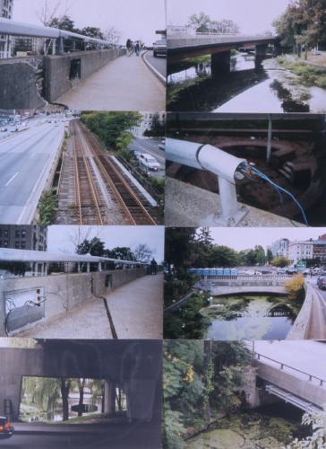
The site visit to Boston and the Fens provided an understanding of the urban context that was not evident from the initial mapping exercise. The relationships between the various systems of the city seem to be directly connected to the quality of the urban environment. Where one system is thoughtfully organized with another system the result is clear from the quality of the place and its resulting use. Where two (or more) systems show a lack of connection and positive relationship between one another a disjuncture in the urban environment is apparent. The lack of connection seems most prevalent at the north end of the site as the watercourse branches towards the Charles River. At this location numerous systems of the infrastructure come together and hierarchies are developed that place certain systems above others. Of particular note is the relationship between the Muddy River and the road systems. At the Boylston St. Bridge the watercourse becomes constricted as it is funneled through the labyrinth of highways, overpasses, railroads and city streets. Just before the Muddy River reaches the Charles River it is disconnected and channeled under Storrow Dr. The result of these constrictions and hierarchies is evident both in the quality of the watercourse and the habitation of the landscape. |
 |
|
| continue | |
| Copyright ©Kathy Poole all rights reserved |